
Carte topographique County Wicklow
Carte interactive
Cliquez sur la carte pour afficher l’altitude.
À propos de cette carte
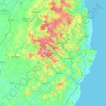
Nom : Carte topographique County Wicklow, altitude, relief.
Lieu : County Wicklow, Leinster, Ireland (52.68198 -6.79229 53.23431 -5.99758)
Altitude moyenne : 166 m
Altitude minimum : 0 m
Altitude maximum : 927 m
The county experiences a narrow annual temperature range. Typical daytime highs range from 17–22 °C (63–72 °F) throughout the county in July and August, with overnight lows in the 11–14 °C (52–57 °F) range, although temperatures in the mountains can be 5–10 °C (41–50 °F) lower. Mean January temperatures range from 7 °C (45 °F) on the coast to 0 °C (32 °F) at high elevations. Precipitation is fairly evenly distributed throughout the year, although the wettest months (October and November) receive roughly twice as much rain as the driest months (February, March and April). The driest area of Wicklow is the northeast corner of the county, which is protected from the prevailing south-westerly winds by the Wicklow Mountains and receives around 750 mm (30 in) of rainfall per year. The coastal region of County Dublin immediately to the north is the driest location in all of Ireland as a result of the rain shadow created by the mountains.
Autres cartes topographiques
Cliquez sur une carte pour visualiser sa topographie, son altitude et son relief.
Newfarm
Newfarm, The Rower, The Municipal District of Callan — Thomastown, County Kilkenny, Leinster, Ireland
Altitude moyenne : 33 m
Blanchardstown
Blanchardstown, Fingal, County Dublin, Leinster, D15 KPW7, Ireland
Altitude moyenne : 61 m
Rathmines
Ireland > County Dublin > Dublin
Rathmines, Rathmines West B Ward 1986, Dublin, County Dublin, Leinster, Ireland
Altitude moyenne : 28 m
Louisburgh
Louisburgh, Westport-Belmullet Municipal District, County Mayo, Connacht, Ireland
Altitude moyenne : 17 m
Ballina
Ballina, Ballina Municipal District, County Mayo, Connacht, Ireland
Altitude moyenne : 19 m
Gunpoint
Gunpoint, Lowertown, West Cork, County Cork, Munster, Ireland
Altitude moyenne : 14 m
Killarney
Killarney, Killarney Municipal District, County Kerry, Munster, Ireland
Altitude moyenne : 57 m
Newbridge
Newbridge, The Municipal District of Kildare — Newbridge, County Kildare, Leinster, Ireland
Altitude moyenne : 95 m
Ballyboden
Ballyboden, South Dublin, County Dublin, Leinster, D14 VY33, Ireland
Altitude moyenne : 83 m
Took
Took, Modelligo, The Municipal District of Dungarvan — Lismore, County Waterford, Munster, Ireland
Altitude moyenne : 169 m
Dún Laoghaire
Dún Laoghaire, Dún Laoghaire-Rathdown, County Dublin, Leinster, A96 T860, Ireland
Altitude moyenne : 21 m
Powderly Lower
Ireland > County Donegal > Kildoney
Powderly Lower, Kildoney, Castlefinn ED, Lifford-Stranorlar Municipal District, County Donegal, Ulster, Ireland
Altitude moyenne : 57 m
Thomastown
Thomastown, The Municipal District of Callan — Thomastown, County Kilkenny, Leinster, Ireland
Altitude moyenne : 44 m
Moyle Beg
Moyle Beg, Cormeen ED, Ballybay-Clones Municipal District, County Monaghan, Ulster, Ireland
Altitude moyenne : 135 m
Waterfall
Waterfall, Inishkenny, Municipal District of Carrigaline, County Cork, Munster, T12 CYF2, Ireland
Altitude moyenne : 96 m
Carlingford
Carlingford, County Louth, Leinster, Ireland
Altitude moyenne : 84 m
Saint Kevins Ward 1986
Ireland > County Dublin > Dublin
Saint Kevins Ward 1986, Dublin, County Dublin, Leinster, Ireland
Altitude moyenne : 18 m
Camira Glebe
Camira Glebe, Rosenallis ED, The Municipal District of Borris-in-Ossory — Mountmellick, County Laois, Leinster, Ireland
Altitude moyenne : 82 m
Letterkenny
Letterkenny, County Donegal, Ulster, Ireland
Altitude moyenne : 92 m
Naas
Naas, The Municipal District of Naas, County Kildare, Leinster, Ireland
Altitude moyenne : 99 m
Kilcullen
Kilcullen, Municipal District of Macroom, County Cork, Munster, Ireland
Altitude moyenne : 216 m
Dunmore
Dunmore, Tuam Municipal District, County Galway, Connacht, Ireland
Altitude moyenne : 63 m
Jerpoint Church
Jerpoint Church, The Municipal District of Callan — Thomastown, County Kilkenny, Leinster, Ireland
Altitude moyenne : 94 m
Clara
Clara, Clara ED, The Municipal District of Tullamore, County Offaly, Leinster, Ireland
Altitude moyenne : 62 m
Listowel Municipal District
Listowel Municipal District, County Kerry, Munster, Ireland
Altitude moyenne : 67 m
Cliffs of Moher
Cliffs of Moher, Ballysteen ED, West Clare Municipal District, County Clare, Munster, Ireland
Altitude moyenne : 55 m
The Glen
Ireland > County Cork > Cork
The Glen, Dublin Hill, The Glen B, Cork, County Cork, Munster, T23 D437, Ireland
Altitude moyenne : 57 m
Holycross
Holycross, The Municipal District of Thurles, County Tipperary, Munster, Ireland
Altitude moyenne : 99 m
The Municipal District of Greystones
The Municipal District of Greystones, County Wicklow, Leinster, Ireland
Altitude moyenne : 89 m
The Municipal District of Bray
The Municipal District of Bray, County Wicklow, Leinster, Ireland
Altitude moyenne : 283 m
Athenry-Oranmore Municipal District
Athenry-Oranmore Municipal District, County Galway, Connacht, Ireland
Altitude moyenne : 42 m
Killaloe Municipal District
Killaloe Municipal District, County Clare, Munster, Ireland
Altitude moyenne : 85 m
Wexford
Wexford, The Borough District of Wexford, County Wexford, Leinster, Ireland
Altitude moyenne : 23 m
Dingle
Dingle, Kenmare Municipal District, County Kerry, Munster, Ireland
Altitude moyenne : 121 m
Connolly
Connolly, Kinturk ED, West Clare Municipal District, County Clare, Munster, Ireland
Altitude moyenne : 96 m
Glenbrook
Glenbrook, Municipal District of Carrigaline, County Cork, Munster, T12 KT5N, Ireland
Altitude moyenne : 50 m
Mother Mountain
Mother Mountain, The Municipal District of Nenagh, County Tipperary, Munster, Ireland
Altitude moyenne : 368 m
Ballymacarbry
Ballymacarbry, The Municipal District of Comeragh, County Waterford, Munster, Ireland
Altitude moyenne : 145 m
Kilkenny
Kilkenny, County Kilkenny, Leinster, Ireland
Altitude moyenne : 62 m
Ruan
Ruan, West Clare Municipal District, County Clare, Munster, Ireland
Altitude moyenne : 22 m
Collinstown
Collinstown, Airport ED, Fingal, County Dublin, Leinster, Ireland
Altitude moyenne : 62 m