
Carte topographique Kilkenny
Carte interactive
Cliquez sur la carte pour afficher l’altitude.
À propos de cette carte
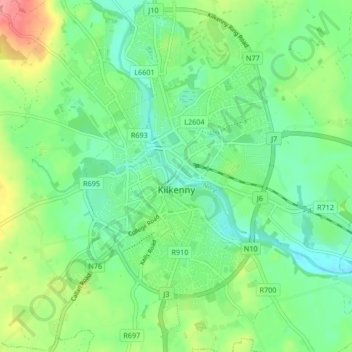
Nom : Carte topographique Kilkenny, altitude, relief.
Lieu : Kilkenny, County Kilkenny, Leinster, Ireland (52.62761 -7.28545 52.67819 -7.20616)
Altitude moyenne : 62 m
Altitude minimum : 36 m
Altitude maximum : 114 m
Kilkenny is situated in the Nore Valley on both banks of the River Nore, at the centre of County Kilkenny in the province of Leinster in the south-east of Ireland. It is 117 kilometres (73 mi) away the capital Dublin and 48 kilometres (30 mi) north from the nearest city Waterford. Wexford is 80 kilometres (50 mi) to the south-east and Limerick is 122 kilometres (76 mi) to the west. The elevation is 60 metres (200 ft) above mean sea level. The area of Kilkenny borough is 3.74 square kilometres (1.44 sq mi). The first edition of the Ordnance Survey map for Kilkenny was in 1837 and is held by the County Library.
Autres cartes topographiques
Cliquez sur une carte pour visualiser sa topographie, son altitude et son relief.
Newfarm
Newfarm, The Rower, The Municipal District of Callan — Thomastown, County Kilkenny, Leinster, Ireland
Altitude moyenne : 33 m
Thomastown
Thomastown, The Municipal District of Callan — Thomastown, County Kilkenny, Leinster, Ireland
Altitude moyenne : 44 m
Jerpoint Church
Jerpoint Church, The Municipal District of Callan — Thomastown, County Kilkenny, Leinster, Ireland
Altitude moyenne : 94 m
Kilmacow
Ireland > County Kilkenny > Kilmacow
Kilmacow, The Municipal District of Piltown, County Kilkenny, Leinster, Ireland
Altitude moyenne : 28 m
The Municipal District of Callan — Thomastown
The Municipal District of Callan — Thomastown, County Kilkenny, Leinster, Ireland
Altitude moyenne : 100 m
Thomastown
Ireland > County Kilkenny > Thomastown
Thomastown, The Municipal District of Callan — Thomastown, County Kilkenny, Leinster, R95 X201, Ireland
Altitude moyenne : 71 m