
Carte topographique Killarney
Carte interactive
Cliquez sur la carte pour afficher l’altitude.
À propos de cette carte
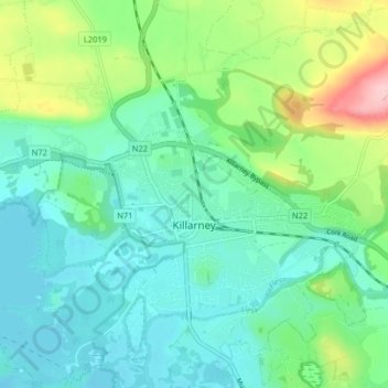
Nom : Carte topographique Killarney, altitude, relief.
Altitude moyenne : 57 m
Altitude minimum : 15 m
Altitude maximum : 180 m
Autres cartes topographiques
Cliquez sur une carte pour visualiser sa topographie, son altitude et son relief.
Listowel Municipal District
Listowel Municipal District, County Kerry, Munster, Ireland
Altitude moyenne : 67 m
Dingle
Dingle, Kenmare Municipal District, County Kerry, Munster, Ireland
Altitude moyenne : 121 m
Glenlea
Glenlea, Ballyheige ED, Listowel Municipal District, County Kerry, Munster, Ireland
Altitude moyenne : 60 m