
Carte topographique Gunpoint
Carte interactive
Cliquez sur la carte pour afficher l’altitude.
À propos de cette carte
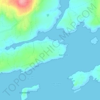
Nom : Carte topographique Gunpoint, altitude, relief.
Lieu : Gunpoint, Lowertown, West Cork, County Cork, Munster, Ireland (51.49498 -9.59944 51.50260 -9.58401)
Altitude moyenne : 14 m
Altitude minimum : -3 m
Altitude maximum : 108 m
Autres cartes topographiques
Cliquez sur une carte pour visualiser sa topographie, son altitude et son relief.
Waterfall
Waterfall, Inishkenny, Municipal District of Carrigaline, County Cork, Munster, T12 CYF2, Ireland
Altitude moyenne : 96 m
Kilcullen
Kilcullen, Municipal District of Macroom, County Cork, Munster, Ireland
Altitude moyenne : 216 m
The Glen
Ireland > County Cork > Cork
The Glen, Dublin Hill, The Glen B, Cork, County Cork, Munster, T23 D437, Ireland
Altitude moyenne : 57 m
Glenbrook
Glenbrook, Municipal District of Carrigaline, County Cork, Munster, T12 KT5N, Ireland
Altitude moyenne : 50 m
Municipal District of Cobh
Municipal District of Cobh, County Cork, Munster, Ireland
Altitude moyenne : 98 m
Glenreagh
Glenreagh, Kilmeen, The Municipal District of Kanturk – Mallow, County Cork, Munster, Ireland
Altitude moyenne : 229 m
Kinsale
Ireland > County Cork > Kinsale
Kinsale, The Municipal District of Bandon – Kinsale, County Cork, Munster, P17 H590, Ireland
Altitude moyenne : 44 m
Rossmore
Rossmore, West Cork, County Cork, Munster, P85 TA48, Ireland
Altitude moyenne : 93 m
Glanmire
Ireland > County Cork > Cork
Glanmire, Cork, County Cork, Munster, T45 X924, Ireland
Altitude moyenne : 58 m