
Carte topographique Blanchardstown
Carte interactive
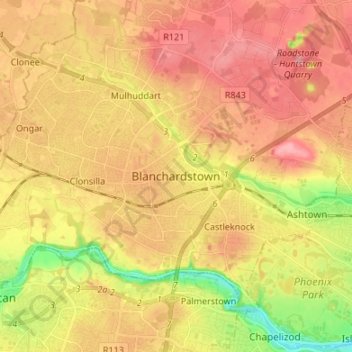
Cliquez sur la carte pour afficher l’altitude.
À propos de cette carte
Nom : Carte topographique Blanchardstown, altitude, relief.
Altitude moyenne : 61 m
Altitude minimum : 4 m
Altitude maximum : 98 m
Blanchardstown was a predominantly rural area, with a small village, in western County Dublin, alongside the neighbouring district of Castleknock. Both areas shared a common history until well into the 19th century, when their development diverged. In A Topographical Dictionary of Ireland, published in 1837, Blanchardstown is described as "a village [..] on the road to Navan, containing 57 houses and 342 inhabitants".
Autres cartes topographiques
Cliquez sur une carte pour visualiser sa topographie, son altitude et son relief.
Rathmines
Ireland > County Dublin > Dublin
Rathmines, Rathmines West B Ward 1986, Dublin, County Dublin, Leinster, Ireland
Altitude moyenne : 28 m
Ballyboden
Ballyboden, South Dublin, County Dublin, Leinster, D14 VY33, Ireland
Altitude moyenne : 83 m
Dún Laoghaire
Dún Laoghaire, Dún Laoghaire-Rathdown, County Dublin, Leinster, A96 T860, Ireland
Altitude moyenne : 21 m
Saint Kevins Ward 1986
Ireland > County Dublin > Dublin
Saint Kevins Ward 1986, Dublin, County Dublin, Leinster, Ireland
Altitude moyenne : 18 m
Collinstown
Collinstown, Airport ED, Fingal, County Dublin, Leinster, Ireland
Altitude moyenne : 62 m
Castleknock
Castleknock, Fingal, County Dublin, Leinster, D15 W9DH, Ireland
Altitude moyenne : 55 m
Swords
Ireland > County Dublin > Swords
Swords, Fingal, County Dublin, Leinster, K67 X8Y2, Ireland
Altitude moyenne : 28 m
Cornelscourt
Ireland > County Dublin > Cornelscourt
Cornelscourt, Dún Laoghaire-Rathdown, County Dublin, Leinster, DUBLIN 18, Ireland
Altitude moyenne : 59 m
South Dublin
South Dublin, County Dublin, Leinster, Ireland
Altitude moyenne : 183 m