
Carte topographique Carlingford
Carte interactive
Cliquez sur la carte pour afficher l’altitude.
À propos de cette carte
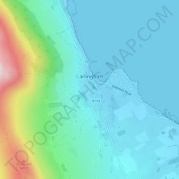
Nom : Carte topographique Carlingford, altitude, relief.
Lieu : Carlingford, County Louth, Leinster, Ireland (54.03068 -6.19431 54.04750 -6.17239)
Altitude moyenne : 84 m
Altitude minimum : -1 m
Altitude maximum : 433 m
Autres cartes topographiques
Cliquez sur une carte pour visualiser sa topographie, son altitude et son relief.
Carlingford
Ireland > County Louth > Carlingford
Carlingford, The Municipal District of Dundalk, County Louth, Leinster, A91 TRR6, Ireland
Altitude moyenne : 84 m