
Carte topographique The Municipal District of Greystones
Carte interactive
Cliquez sur la carte pour afficher l’altitude.
À propos de cette carte
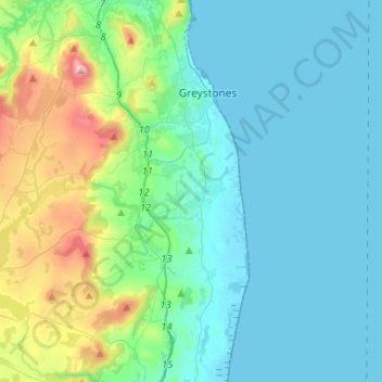
Nom : Carte topographique The Municipal District of Greystones, altitude, relief.
Altitude moyenne : 89 m
Altitude minimum : -1 m
Altitude maximum : 487 m
Autres cartes topographiques
Cliquez sur une carte pour visualiser sa topographie, son altitude et son relief.
The Municipal District of Bray
The Municipal District of Bray, County Wicklow, Leinster, Ireland
Altitude moyenne : 283 m
Blessington
Blessington, County Wicklow, Leinster, Ireland
Altitude moyenne : 205 m
Donard
Ireland > County Wicklow > Donard
Donard, The Municipal District of Baltinglass, County Wicklow, Leinster, W91 TW42, Ireland
Altitude moyenne : 218 m