
Carte topographique Thomastown
Carte interactive
Cliquez sur la carte pour afficher l’altitude.
À propos de cette carte
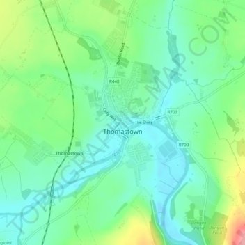
Nom : Carte topographique Thomastown, altitude, relief.
Altitude moyenne : 44 m
Altitude minimum : 9 m
Altitude maximum : 128 m
Autres cartes topographiques
Cliquez sur une carte pour visualiser sa topographie, son altitude et son relief.
Newfarm
Newfarm, The Rower, The Municipal District of Callan — Thomastown, County Kilkenny, Leinster, Ireland
Altitude moyenne : 33 m
Jerpoint Church
Jerpoint Church, The Municipal District of Callan — Thomastown, County Kilkenny, Leinster, Ireland
Altitude moyenne : 94 m
Kilkenny
Kilkenny, County Kilkenny, Leinster, Ireland
Altitude moyenne : 62 m
Kilmacow
Ireland > County Kilkenny > Kilmacow
Kilmacow, The Municipal District of Piltown, County Kilkenny, Leinster, Ireland
Altitude moyenne : 28 m
The Municipal District of Callan — Thomastown
The Municipal District of Callan — Thomastown, County Kilkenny, Leinster, Ireland
Altitude moyenne : 100 m
Thomastown
Ireland > County Kilkenny > Thomastown
Thomastown, The Municipal District of Callan — Thomastown, County Kilkenny, Leinster, R95 X201, Ireland
Altitude moyenne : 71 m