
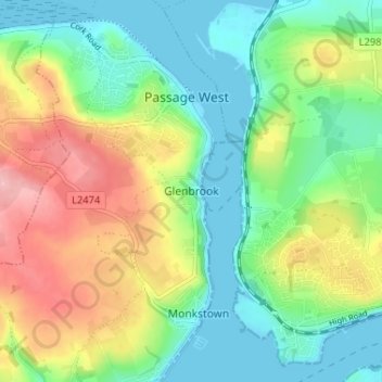
Carte topographique Glenbrook
Carte interactive
Cliquez sur la carte pour afficher l’altitude.
À propos de cette carte
Nom : Carte topographique Glenbrook, altitude, relief.
Altitude moyenne : 50 m
Altitude minimum : -2 m
Altitude maximum : 135 m
Autres cartes topographiques
Cliquez sur une carte pour visualiser sa topographie, son altitude et son relief.
Gunpoint
Gunpoint, Lowertown, West Cork, County Cork, Munster, Ireland
Altitude moyenne : 14 m
Waterfall
Waterfall, Inishkenny, Municipal District of Carrigaline, County Cork, Munster, T12 CYF2, Ireland
Altitude moyenne : 96 m
Kilcullen
Kilcullen, Municipal District of Macroom, County Cork, Munster, Ireland
Altitude moyenne : 216 m
The Glen
Ireland > County Cork > Cork
The Glen, Dublin Hill, The Glen B, Cork, County Cork, Munster, T23 D437, Ireland
Altitude moyenne : 57 m
Municipal District of Cobh
Municipal District of Cobh, County Cork, Munster, Ireland
Altitude moyenne : 98 m
Glenreagh
Glenreagh, Kilmeen, The Municipal District of Kanturk – Mallow, County Cork, Munster, Ireland
Altitude moyenne : 229 m
Kinsale
Ireland > County Cork > Kinsale
Kinsale, The Municipal District of Bandon – Kinsale, County Cork, Munster, P17 H590, Ireland
Altitude moyenne : 44 m
Rossmore
Rossmore, West Cork, County Cork, Munster, P85 TA48, Ireland
Altitude moyenne : 93 m
Glanmire
Ireland > County Cork > Cork
Glanmire, Cork, County Cork, Munster, T45 X924, Ireland
Altitude moyenne : 58 m