
Carte topographique Dunmore
Carte interactive
Cliquez sur la carte pour afficher l’altitude.
À propos de cette carte
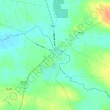
Nom : Carte topographique Dunmore, altitude, relief.
Altitude moyenne : 63 m
Altitude minimum : 50 m
Altitude maximum : 88 m
Autres cartes topographiques
Cliquez sur une carte pour visualiser sa topographie, son altitude et son relief.
Athenry-Oranmore Municipal District
Athenry-Oranmore Municipal District, County Galway, Connacht, Ireland
Altitude moyenne : 42 m
Taylor's Hill
Ireland > County Galway > Galway City
Taylor's Hill, Galway City, County Galway, Connacht, Ireland
Altitude moyenne : 16 m
Menlo
Ireland > County Galway > Menlo
Menlo, County Galway, Connacht, H91 CF90, Ireland
Altitude moyenne : 22 m
Galway City
Ireland > County Galway > Galway City
Galway City, County Galway, Connacht, Ireland
Altitude moyenne : 15 m
Crowsnest
Crowsnest, Lismanny ED, Ballinasloe Municipal District, County Galway, Connacht, Ireland
Altitude moyenne : 67 m