
Carte topographique Killaloe Municipal District
Carte interactive
Cliquez sur la carte pour afficher l’altitude.
À propos de cette carte
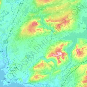
Nom : Carte topographique Killaloe Municipal District, altitude, relief.
Lieu : Killaloe Municipal District, County Clare, Munster, Ireland (52.71607 -8.95344 53.04215 -8.28242)
Altitude moyenne : 85 m
Altitude minimum : -2 m
Altitude maximum : 530 m
Autres cartes topographiques
Cliquez sur une carte pour visualiser sa topographie, son altitude et son relief.
Cliffs of Moher
Cliffs of Moher, Ballysteen ED, West Clare Municipal District, County Clare, Munster, Ireland
Altitude moyenne : 55 m
Connolly
Connolly, Kinturk ED, West Clare Municipal District, County Clare, Munster, Ireland
Altitude moyenne : 96 m
Ruan
Ruan, West Clare Municipal District, County Clare, Munster, Ireland
Altitude moyenne : 22 m
Broadford
Broadford, Kilseily ED, Killaloe Municipal District, County Clare, Munster, Ireland
Altitude moyenne : 95 m