
Carte topographique Cao Bằng Province
Carte interactive
Cliquez sur la carte pour afficher l’altitude.
À propos de cette carte
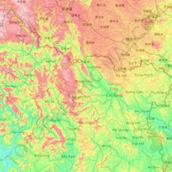
Nom : Carte topographique Cao Bằng Province, altitude, relief.
Lieu : Cao Bằng Province, Vietnam (22.35692 105.26671 23.11879 106.83765)
Altitude moyenne : 638 m
Altitude minimum : 36 m
Altitude maximum : 1 868 m
The Peninsular valley of Cao Bằng province is formed between the Bằng Giang and Hien rivers. The two rivers confluence to the northwest of the town. In the war with China the town was damaged in 1979 and has been since rebuilt. The market in Cao Bằng town is believed to be the largest in Vietnam. Cao Bằng town is located on Highway 3 and is 270 kilometres (170 mi) from Hanoi. The road from Nao Pac to Cao Bằng passes through the Cao Bắc Pass. Since the elevation of the town is 300 metres (980 ft) it has a salubrious temperate climate throughout the year.
Autres cartes topographiques
Cliquez sur une carte pour visualiser sa topographie, son altitude et son relief.
Xã Mê Linh
Vietnam > Lâm Đồng Province > Lâm Hà District
Xã Mê Linh, Lâm Hà District, Lâm Đồng Province, Vietnam
Altitude moyenne : 1 157 m
Phu Quoc Island
Phu Quoc Island, Kiên Giang Province, Vietnam
Altitude moyenne : 17 m
Buon Ma Thuot
Buon Ma Thuot, Đắk Lắk Province, 63107, Vietnam
Altitude moyenne : 442 m
Côn Sơn Island
Vietnam > Bà Rịa - Vũng Tàu Province > Con Dao
Côn Sơn Island, Con Dao, Côn Đảo District, Bà Rịa - Vũng Tàu Province, Vietnam
Altitude moyenne : 2 m
Green Island
Vietnam > Bà Rịa - Vũng Tàu Province
Green Island, Bà Rịa - Vũng Tàu Province, Vietnam
Altitude moyenne : 1 m
Măng Đen
Vietnam > Kon Tum province > Kon Plông District
Măng Đen, Kon Plông District, Kon Tum Province, Vietnam
Altitude moyenne : 1 131 m
Tân Lạc District
Tân Lạc District, Hoà Bình province, Vietnam
Altitude moyenne : 416 m
Phường Sông Đà
Vietnam > Điện Biên Province > Mường Lay
Phường Sông Đà, Mường Lay, Điện Biên Province, Vietnam
Altitude moyenne : 603 m
Ninh Bình
Ninh Bình, Ninh Binh province, 08000, Vietnam
Altitude moyenne : 5 m
Thị trấn Bình Phú
Thị trấn Bình Phú, Cai Lậy District, Tien Giang province, Vietnam
Altitude moyenne : 4 m
Thai Nguyen City
Vietnam > Thai Nguyen province
Thai Nguyen City, Thai Nguyen province, 20000, Vietnam
Altitude moyenne : 40 m