
Carte topographique Ninh Thuan province
Carte interactive
Cliquez sur la carte pour afficher l’altitude.
À propos de cette carte
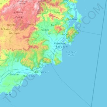
Nom : Carte topographique Ninh Thuan province, altitude, relief.
Lieu : Ninh Thuan province, Vietnam (10.76308 108.55166 12.16453 109.53737)
Altitude moyenne : 282 m
Altitude minimum : -2 m
Altitude maximum : 2 229 m
Ninh Thuận's topography is typical for the South Central Coast in that high mountains are located not only near the western border to the Central Highlands, but also near the coast, the highest of which is Chúa mountain (Vietnamese: Núi Chúa) at 1,040 metres (3,410 ft) in the north east of the province. Several other peaks with heights up to 643 metres (2,110 ft), including Đá Bạc mountain (Vietnamese: Núi Đá Bạc) in the south, are located along the coast. The highest mountains are located at the borders to Khánh Hòa province and Lâm Đồng province, with three mountains of over 1,600 metres (5,200 ft) and the highest at 1,652 metres (5,420 ft), Sương Mù mountain (Vietnamese: Núi Sương Mù). Only a small part of the province around Phan Rang has elevations of under 50 metres (160 ft). The province's major river is the Dinh River, which flows through the main lowland of the province as well as Phan Rang. It has several tributaries in the province and is connected to Don Duong Lake in Lâm Đồng province.
Autres cartes topographiques
Cliquez sur une carte pour visualiser sa topographie, son altitude et son relief.
Xã Mê Linh
Vietnam > Lâm Đồng Province > Lâm Hà District
Xã Mê Linh, Lâm Hà District, Lâm Đồng Province, Vietnam
Altitude moyenne : 1 157 m
Phu Quoc Island
Phu Quoc Island, Kiên Giang Province, Vietnam
Altitude moyenne : 17 m
Buon Ma Thuot
Buon Ma Thuot, Đắk Lắk Province, 63107, Vietnam
Altitude moyenne : 442 m
Côn Sơn Island
Vietnam > Bà Rịa - Vũng Tàu Province > Con Dao
Côn Sơn Island, Con Dao, Côn Đảo District, Bà Rịa - Vũng Tàu Province, Vietnam
Altitude moyenne : 2 m
Green Island
Vietnam > Bà Rịa - Vũng Tàu Province
Green Island, Bà Rịa - Vũng Tàu Province, Vietnam
Altitude moyenne : 1 m
Măng Đen
Vietnam > Kon Tum province > Kon Plông District
Măng Đen, Kon Plông District, Kon Tum Province, Vietnam
Altitude moyenne : 1 131 m
Tân Lạc District
Tân Lạc District, Hoà Bình province, Vietnam
Altitude moyenne : 416 m
Phường Sông Đà
Vietnam > Điện Biên Province > Mường Lay
Phường Sông Đà, Mường Lay, Điện Biên Province, Vietnam
Altitude moyenne : 603 m
Ninh Bình
Ninh Bình, Ninh Binh province, 08000, Vietnam
Altitude moyenne : 5 m
Thị trấn Bình Phú
Thị trấn Bình Phú, Cai Lậy District, Tien Giang province, Vietnam
Altitude moyenne : 4 m
Thai Nguyen City
Vietnam > Thai Nguyen province
Thai Nguyen City, Thai Nguyen province, 20000, Vietnam
Altitude moyenne : 40 m