
Carte topographique Lạng Sơn Province
Carte interactive
Cliquez sur la carte pour afficher l’altitude.
À propos de cette carte
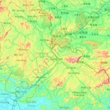
Nom : Carte topographique Lạng Sơn Province, altitude, relief.
Lieu : Lạng Sơn Province, Vietnam (21.32515 106.09538 22.46146 107.36410)
Altitude moyenne : 290 m
Altitude minimum : 4 m
Altitude maximum : 1 461 m
The province is set in karstic limestone mountains and valleys. Mountains and forests comprise 80% of the province's area. The province measures approximately 123 kilometres from north to south and 126 kilometres from west to east. The average altitude of the province is 252 metres (827 ft) above sea level. The lowest point in the province is 20 metres (66 ft) towards the south of Hữu Lũng District and the highest point is at Mount Mẫu Sơn, which is 1,541 metres (5,056 ft). Mẫu Sơn is to the east of the town of Lạng Sơn by 30 kilometres (19 mi), and is surrounded by a series of small peaks; snow sometimes falls on these peaks in winter. The Bac Son Mountains are located in the province and are calcareous in nature. Fertile valleys are framed by high mountain ridges, creating a scenic landscape.
Autres cartes topographiques
Cliquez sur une carte pour visualiser sa topographie, son altitude et son relief.
Xã Mê Linh
Vietnam > Lâm Đồng Province > Lâm Hà District
Xã Mê Linh, Lâm Hà District, Lâm Đồng Province, Vietnam
Altitude moyenne : 1 157 m
Phu Quoc Island
Phu Quoc Island, Kiên Giang Province, Vietnam
Altitude moyenne : 17 m
Buon Ma Thuot
Buon Ma Thuot, Đắk Lắk Province, 63107, Vietnam
Altitude moyenne : 442 m
Côn Sơn Island
Vietnam > Bà Rịa - Vũng Tàu Province > Con Dao
Côn Sơn Island, Con Dao, Côn Đảo District, Bà Rịa - Vũng Tàu Province, Vietnam
Altitude moyenne : 2 m
Green Island
Vietnam > Bà Rịa - Vũng Tàu Province
Green Island, Bà Rịa - Vũng Tàu Province, Vietnam
Altitude moyenne : 1 m
Măng Đen
Vietnam > Kon Tum province > Kon Plông District
Măng Đen, Kon Plông District, Kon Tum Province, Vietnam
Altitude moyenne : 1 131 m
Tân Lạc District
Tân Lạc District, Hoà Bình province, Vietnam
Altitude moyenne : 416 m
Phường Sông Đà
Vietnam > Điện Biên Province > Mường Lay
Phường Sông Đà, Mường Lay, Điện Biên Province, Vietnam
Altitude moyenne : 603 m
Ninh Bình
Ninh Bình, Ninh Binh province, 08000, Vietnam
Altitude moyenne : 5 m
Thị trấn Bình Phú
Thị trấn Bình Phú, Cai Lậy District, Tien Giang province, Vietnam
Altitude moyenne : 4 m
Thai Nguyen City
Vietnam > Thai Nguyen province
Thai Nguyen City, Thai Nguyen province, 20000, Vietnam
Altitude moyenne : 40 m