
Carte topographique Bac Giang Province
Carte interactive
Cliquez sur la carte pour afficher l’altitude.
À propos de cette carte
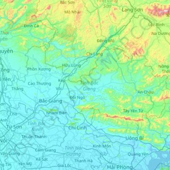
Nom : Carte topographique Bac Giang Province, altitude, relief.
Lieu : Bac Giang Province, Vietnam (21.12195 105.88058 21.62627 107.03347)
Altitude moyenne : 178 m
Altitude minimum : -2 m
Altitude maximum : 1 476 m
The terrain is moderately mountainous, lying between the high mountains to the north and the Red River Delta to the south. Although a large part of the terrain is mountainous most of it is not isolated. The region to the northern end of the province is mountainous uncleared forest. To the east and southeast of the province is Đông Triều and Mount Yên Tử, located within the Yên Tử Nature Reserve. The elevation of the province is mostly in the 300–900 metres (980–2,950 ft) range, with a maximum of 1,068 metres (3,504 ft) (Mount Yên Tử). To the northeastern end of the province, along the border with Quảng Ninh there is the Khe Rỗ forest, spanning 71.53 km2, with a rich biodiversity.
Autres cartes topographiques
Cliquez sur une carte pour visualiser sa topographie, son altitude et son relief.
Xã Mê Linh
Vietnam > Lâm Đồng Province > Lâm Hà District
Xã Mê Linh, Lâm Hà District, Lâm Đồng Province, Vietnam
Altitude moyenne : 1 157 m
Phu Quoc Island
Phu Quoc Island, Kiên Giang Province, Vietnam
Altitude moyenne : 17 m
Buon Ma Thuot
Buon Ma Thuot, Đắk Lắk Province, 63107, Vietnam
Altitude moyenne : 442 m
Côn Sơn Island
Vietnam > Bà Rịa - Vũng Tàu Province > Con Dao
Côn Sơn Island, Con Dao, Côn Đảo District, Bà Rịa - Vũng Tàu Province, Vietnam
Altitude moyenne : 2 m
Green Island
Vietnam > Bà Rịa - Vũng Tàu Province
Green Island, Bà Rịa - Vũng Tàu Province, Vietnam
Altitude moyenne : 1 m
Măng Đen
Vietnam > Kon Tum province > Kon Plông District
Măng Đen, Kon Plông District, Kon Tum Province, Vietnam
Altitude moyenne : 1 131 m
Tân Lạc District
Tân Lạc District, Hoà Bình province, Vietnam
Altitude moyenne : 416 m
Phường Sông Đà
Vietnam > Điện Biên Province > Mường Lay
Phường Sông Đà, Mường Lay, Điện Biên Province, Vietnam
Altitude moyenne : 603 m
Ninh Bình
Ninh Bình, Ninh Binh province, 08000, Vietnam
Altitude moyenne : 5 m
Thị trấn Bình Phú
Thị trấn Bình Phú, Cai Lậy District, Tien Giang province, Vietnam
Altitude moyenne : 4 m
Thai Nguyen City
Vietnam > Thai Nguyen province
Thai Nguyen City, Thai Nguyen province, 20000, Vietnam
Altitude moyenne : 40 m