
Carte topographique Đà Lạt
Carte interactive
Cliquez sur la carte pour afficher l’altitude.
À propos de cette carte
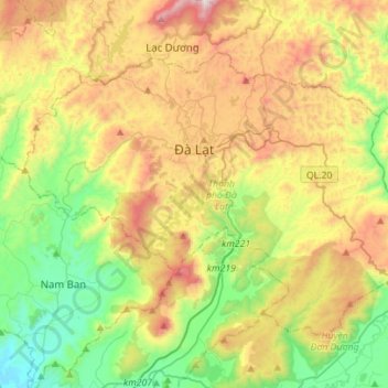
Nom : Carte topographique Đà Lạt, altitude, relief.
Lieu : Đà Lạt, Lâm Đồng Province, Vietnam (11.80798 108.31521 12.00852 108.59461)
Altitude moyenne : 1 322 m
Altitude minimum : 833 m
Altitude maximum : 2 077 m
Autres cartes topographiques
Cliquez sur une carte pour visualiser sa topographie, son altitude et son relief.
Xã Mê Linh
Vietnam > Lâm Đồng Province > Lâm Hà District
Xã Mê Linh, Lâm Hà District, Lâm Đồng Province, Vietnam
Altitude moyenne : 1 157 m
Ma Am
Vietnam > Lâm Đồng Province > Ma Am
Ma Am, Đức Trọng District, Lâm Đồng Province, Vietnam
Altitude moyenne : 955 m
Đơn Dương District
Đơn Dương District, Lâm Đồng Province, Vietnam
Altitude moyenne : 1 078 m
Dalat
Vietnam > Lâm Đồng Province > Dalat
Dalat, Đà Lạt District, Lâm Đồng Province, 67000, Vietnam
Altitude moyenne : 1 360 m