
Carte topographique Haldwani
Carte interactive
Cliquez sur la carte pour afficher l’altitude.
À propos de cette carte
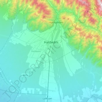
Nom : Carte topographique Haldwani, altitude, relief.
Lieu : Haldwani, Nainital District, Uttarakhand, India (29.08483 79.36225 29.29770 79.66641)
Altitude moyenne : 526 m
Altitude minimum : 227 m
Altitude maximum : 2 112 m
Haldwani is located at 29°13′N 79°31′E / 29.22°N 79.52°E / 29.22; 79.52, in the Nainital district on the right bank of the Gaula River. Geologically, Haldwani is settled on a piedmont grade (called Bhabhar) where the mountain rivers go underground to re-emerge in the Indo-Gangetic plain. The Haldwani Bhabhar stretches horizontally, surrounded by the regions of Ramnagar and Tanakpur and lies between the Shivalik hills to the north and the Terai region of Rudrapur to the south. The average land elevation is 424 m (1,391 ft) above sea level. According to the Bureau of Indian Standards, Haldwani falls under seismic zone 4, in a scale of 2 to 5 (in order of increasing vulnerability to earthquakes).
Autres cartes topographiques
Cliquez sur une carte pour visualiser sa topographie, son altitude et son relief.
Lake Vasuki Tal
India > Uttarakhand > Ukhimath > Kedarnath
Lake Vasuki Tal, Kedarnath, Ukhimath, Rudraprayag District, Uttarakhand, India
Altitude moyenne : 4 303 m
Jamroli
India > Uttarakhand > Ghansali
Jamroli, Ghansali, Tehri Garhwal District, Uttarakhand, India
Altitude moyenne : 2 140 m
Yamunotri
India > Uttarakhand > Rajgarhi
Yamunotri, Rajgarhi, Uttarkashi District, Uttarakhand, India
Altitude moyenne : 3 692 m
Joshimath Tehsil
Joshimath Tehsil, Chamoli District, Uttarakhand, India
Altitude moyenne : 4 423 m
Dhumakot
India > Uttarakhand > Dhoomakot
Dhumakot, Dhoomakot, Pauri Garhwal District, Uttarakhand, 246277, India
Altitude moyenne : 1 605 m
Gangotri Glacier
India > Uttarakhand > Bhatwari
Gangotri Glacier, Bhatwari, Uttarkashi District, Uttarakhand, India
Altitude moyenne : 5 259 m
Kotdwar
India > Uttarakhand > Kotdwara
Kotdwar, Kotdwara, Pauri Garhwal District, Uttarakhand, 246149, India
Altitude moyenne : 471 m
Lambgaon
India > Uttarakhand > Pratapnagar
Lambgaon, Pratapnagar, Tehri Garhwal, Uttarakhand, 249165, India
Altitude moyenne : 1 497 m
Retali
India > Uttarakhand > Chamoli Tehsil > Gadora
Retali, Gadora, Chamoli Tehsil, Chamoli district, Uttarakhand, 246472, India
Altitude moyenne : 1 570 m
Joshimath
India > Uttarakhand > Joshimath Tehsil
Joshimath, Joshimath Tehsil, Chamoli district, Uttarakhand, India
Altitude moyenne : 2 272 m
pipalkoti
India > Uttarakhand > Srinagar > Khanda
pipalkoti, Khanda, Srinagar, Pauri Garhwal, Uttarakhand, 249127, India
Altitude moyenne : 885 m
Elephant Pound Rajaji National park Uttrakhand
India > Uttarakhand > Yamkeshwar
Elephant Pound Rajaji National park Uttrakhand, Yamkeshwar, Pauri Garhwal, Uttarakhand, India
Altitude moyenne : 455 m
Gangani
India > Uttarakhand > Rajgarhi
Gangani, Rajgarhi, Uttarkashi district, Uttarakhand, India
Altitude moyenne : 1 551 m
Kinwani
India > Uttarakhand > Narendra Nagar > Narendranagar
Kinwani, Narendranagar, Narendra Nagar, Tehri Garhwal, Uttarakhand, 249175, India
Altitude moyenne : 903 m
pilkhi
India > Uttarakhand > Ghansali
pilkhi, Ghansali, Tehri Garhwal, Uttarakhand, 249181, India
Altitude moyenne : 1 156 m
Ghansali
India > Uttarakhand > Ghansali
Ghansali, Tehri Garhwal, Uttarakhand, India
Altitude moyenne : 1 111 m
Mori
Mori, Uttarkashi district, Uttarakhand, 249128, India
Altitude moyenne : 3 191 m
Dehradun
India > Uttarakhand > Dehradun
Dehradun, Dehradun District, Uttarakhand, 248001, India
Altitude moyenne : 904 m
sujjargaon
India > Uttarakhand > Pratapnagar > Kyari(002)
sujjargaon, Kyari(002), Pratapnagar, Tehri Garhwal, Uttarakhand, 249165, India
Altitude moyenne : 1 479 m
Hardeol
India > Uttarakhand > Joshimath Tehsil
Hardeol, Joshimath Tehsil, Chamoli district, Uttarakhand, India
Altitude moyenne : 6 228 m
Gangolihāt
India > Uttarakhand > Gangolihat
Gangolihāt, Gangolihat, Pithoragarh district, Uttarakhand, 262522, India
Altitude moyenne : 1 532 m
Baniyari
India > Uttarakhand > Rudraprayag > Agastmuni
Baniyari, Agastmuni, Rudraprayag, Uttarakhand, 246421, India
Altitude moyenne : 1 150 m
Uttarkashi
India > Uttarakhand > Bhatwari
Uttarkashi, Bhatwari, Uttarkashi district, Uttarakhand, 249193, India
Altitude moyenne : 1 619 m
Barkot
India > Uttarakhand > Rajgarhi
Barkot, Rajgarhi, Uttarkashi district, Uttarakhand, India
Altitude moyenne : 1 628 m
Khatīma
Khatīma, Udham Singh Nagar, Uttarakhand, 262308, India
Altitude moyenne : 219 m
Laksar
India > Uttarakhand > Laksar > Laksar
Laksar, Haridwar, Uttarakhand, India
Altitude moyenne : 238 m
Jalai
India > Uttarakhand > Ukhimath > Jalai
Jalai, Ukhimath, Rudraprayag, Uttarakhand, 246419, India
Altitude moyenne : 1 311 m
Lansdowne
India > Uttarakhand > Lansdowne
Lansdowne, Pauri Garhwal, Uttarakhand, India
Altitude moyenne : 1 025 m
satkhol
India > Uttarakhand > satkhol
satkhol, Kosya Kutauli, Nainital, Uttarakhand, 263138, India
Altitude moyenne : 1 704 m
Pithoragarh
India > Uttarakhand > Pithoragarh Tehsil
Pithoragarh, Pithoragarh Tehsil, Pithoragarh district, Uttarakhand, 262500, India
Altitude moyenne : 1 617 m
dhanaula
India > Uttarakhand > Dehradun > dhanaula
dhanaula, Dehradun, Uttarakhand, 248009, India
Altitude moyenne : 1 011 m
Mohabbewāla
India > Uttarakhand > Dehradun > Dehradun > Mohabbewāla
Mohabbewāla, Dehradun, Uttarakhand, 248001, India
Altitude moyenne : 626 m
Haridwar
India > Uttarakhand > Hardwar
Haridwar, Hardwar, Haridwar District, Uttarakhand, 249401, India
Altitude moyenne : 360 m
Pindar Glacier
Pindar Glacier, Bageshwar, Uttarakhand, India
Altitude moyenne : 4 447 m
Milam Glacier
Milam Glacier, Pithoragarh, Uttarakhand, India
Altitude moyenne : 5 223 m
Gangotri
India > Uttarakhand > Gangotri
Gangotri, Uttarkashi, Uttarakhand, India
Altitude moyenne : 4 139 m
Bāgeshwar
India > Uttarakhand > Bāgeshwar
Bāgeshwar, Bageshwar, Uttarakhand, 263642, India
Altitude moyenne : 1 154 m