
Carte topographique Dehradun
Carte interactive
Cliquez sur la carte pour afficher l’altitude.
À propos de cette carte
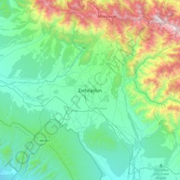
Nom : Carte topographique Dehradun, altitude, relief.
Lieu : Dehradun, Dehradun District, Uttarakhand, 248001, India (30.16556 77.88368 30.48556 78.20368)
Altitude moyenne : 904 m
Altitude minimum : 402 m
Altitude maximum : 2 568 m
The city stands at an elevation of approximately 700 metres (2,300 ft) above sea level. Also known as the ‘Abode of Drona’, Dehradun has been an important centre for Garhwal rulers which was captured by the British. Often referred as the gateway to Mussorie. Uttarakhand Police is the main law enforcement agency in the city.
Autres cartes topographiques
Cliquez sur une carte pour visualiser sa topographie, son altitude et son relief.
dhanaula
India > Uttarakhand > Dehradun > dhanaula
dhanaula, Dehradun, Uttarakhand, 248009, India
Altitude moyenne : 1 011 m
Mohabbewāla
India > Uttarakhand > Dehradun > Dehradun > Mohabbewāla
Mohabbewāla, Dehradun, Uttarakhand, 248001, India
Altitude moyenne : 626 m