
Carte topographique Kyustendil
Carte interactive
Cliquez sur la carte pour afficher l’altitude.
À propos de cette carte
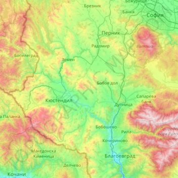
Nom : Carte topographique Kyustendil, altitude, relief.
Lieu : Kyustendil, Bulgaria (42.02087 22.35980 42.64896 23.52946)
Altitude moyenne : 989 m
Altitude minimum : 309 m
Altitude maximum : 2 716 m
For the most part, the climate is transcontinental, but at higher altitudes it is mountainous. The main drainage river is Struma whose subsidiaries are the Treklyanska, Dragovishtitsa, Bistritsa, Slokoshtitsa, Novoselska, Dzherman and Rila rivers. Subterranean water levels are relatively high. Near the village of Kamenichka Skakavitsa, the Golemi dol river forms a 70-meter-high waterfall. The Dyakovo, Bersin, Drenov dol and Bagrentsi artificial lakes (dams) are chiefly used for irrigation purposes. Soil composition is most favorable for the traditionally developed fruit-growing.
Autres cartes topographiques
Cliquez sur une carte pour visualiser sa topographie, son altitude et son relief.
River Park
Bulgaria > Sofia-City > Vitosha
River Park, Vitosha, Sofia City, Sofia-City, Bulgaria
Altitude moyenne : 746 m
Graf Ignatievo
Graf Ignatievo, Maritsa, Plovdiv, 4198, Bulgaria
Altitude moyenne : 191 m
Драгойна
Bulgaria > Plovdiv > Dragoynovo
Драгойна, Dragoynovo, Parvomai, Plovdiv, 4293, Bulgaria
Altitude moyenne : 534 m
Panichishte
Panichishte, Sapareva Bania, Kyustendil, 2650, Bulgaria
Altitude moyenne : 1 326 m