
Carte topographique Sofia
Carte interactive
Cliquez sur la carte pour afficher l’altitude.
À propos de cette carte
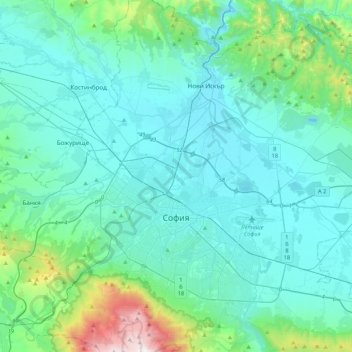
Nom : Carte topographique Sofia, altitude, relief.
Lieu : Sofia, Sofia City, Sofia-City, Bulgaria (42.60309 23.19509 42.78679 23.43248)
Altitude moyenne : 644 m
Altitude minimum : 505 m
Altitude maximum : 1 890 m
Sofia City Province has an area of 1344 km2, while the surrounding and much bigger Sofia Province is 7,059 km2. Sofia's development as a significant settlement owes much to its central position in the Balkans. It is situated in western Bulgaria, at the northern foot of the Vitosha mountain, in the Sofia Valley that is surrounded by the Balkan mountains to the north. The valley has an average altitude of 550 metres (1,800 ft). Sofia is the second highest capital of the European Union (after Madrid) and the third highest capital of Europe (after Andorra la Vella and Madrid). Unlike most European capitals, Sofia does not straddle any large river, but is surrounded by comparatively high mountains on all sides. Three mountain passes lead to the city, which have been key roads since antiquity, Vitosha being the watershed between Black and Aegean Seas.
Autres cartes topographiques
Cliquez sur une carte pour visualiser sa topographie, son altitude et son relief.
River Park
Bulgaria > Sofia-City > Vitosha
River Park, Vitosha, Sofia City, Sofia-City, Bulgaria
Altitude moyenne : 746 m
Svetovrachene
Bulgaria > Sofia-City > Novi Iskar
Svetovrachene, Novi Iskar, Sofia City, Sofia-City, 1222, Bulgaria
Altitude moyenne : 525 m