Géolocaliser

Carte topographique Kyustendil

Carte interactive

Cliquez sur la carte pour afficher l’altitude.

À propos de cette carte
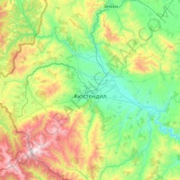
Nom : Carte topographique Kyustendil, altitude, relief.

Lieu : Kyustendil, Bulgaria (42.09792 22.35980 42.48571 22.89789)

Altitude moyenne : 939 m

Altitude minimum : 402 m

Altitude maximum : 2 246 m

Kyustendil is a national balneological resort at an altitude of 600 metres. There are more than 40 mineral springs in the town. The waters have a high content of sulfite compounds. These are used for the treatment of the locomotory system, gynecological and other kinds of diseases. The resort region includes several baths, balneological complexes and others.

Wikipedia (CC-BY-SA 3.0)

Autres cartes topographiques

Cliquez sur une carte pour visualiser sa topographie, son altitude et son relief.

Panichishte

Bulgaria > Kyustendil

Panichishte, Sapareva Bania, Kyustendil, 2650, Bulgaria

Altitude moyenne : 1 326 m

Dupnitsa

Bulgaria > Kyustendil > Dupnitsa

Dupnitsa, Kyustendil, 2604, Bulgaria

Altitude moyenne : 848 m