
Carte topographique Đồng Hới
Carte interactive
Cliquez sur la carte pour afficher l’altitude.
À propos de cette carte
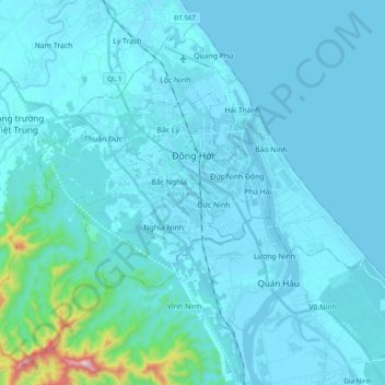
Nom : Carte topographique Đồng Hới, altitude, relief.
Lieu : Đồng Hới, Quang Binh province, Vietnam (17.36566 106.49234 17.53000 106.68640)
Altitude moyenne : 45 m
Altitude minimum : -2 m
Altitude maximum : 683 m
The city has diverse topographical and geological features, including hill, mountainous, half mountainous, coastal plains and coastal sand dunes.
Autres cartes topographiques
Cliquez sur une carte pour visualiser sa topographie, son altitude et son relief.
Gia Ninh
Vietnam > Quang Binh province > Quảng Ninh District
Gia Ninh, Quảng Ninh District, Quảng Bình Province, Vietnam
Altitude moyenne : 9 m
Sơn Lý
Vietnam > Quang Binh province > Bố Trạch District
Sơn Lý, Bố Trạch District, Quang Binh province, Vietnam
Altitude moyenne : 34 m
Phong Nha-Kẻ Bàng National Park
Phong Nha-Kẻ Bàng National Park, Quang Binh province, Vietnam
Altitude moyenne : 424 m
Son Doong Cave
Vietnam > Quang Binh province > Bố Trạch
Son Doong Cave, West Ho Chi Minh Highway, Bố Trạch, Quang Binh province, Vietnam
Altitude moyenne : 487 m
Lệ Thủy District
Lệ Thủy District, Quang Binh province, Vietnam
Altitude moyenne : 171 m
Quảng Ninh District
Quảng Ninh District, Quang Binh province, Vietnam
Altitude moyenne : 308 m
Kiến Giang
Vietnam > Quang Binh province > Lệ Thủy District > Kiến Giang
Kiến Giang, Lệ Thủy District, Quang Binh province, Vietnam
Altitude moyenne : 3 m
Bố Trạch District
Bố Trạch District, Quảng Bình Province, Vietnam
Altitude moyenne : 356 m
Phong Nha Town
Vietnam > Quang Binh province > Bố Trạch District
Phong Nha Town, Bố Trạch District, Quảng Bình Province, Vietnam
Altitude moyenne : 66 m