
Carte topographique Lệ Thủy District
Carte interactive
Cliquez sur la carte pour afficher l’altitude.
À propos de cette carte
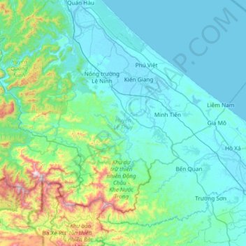
Nom : Carte topographique Lệ Thủy District, altitude, relief.
Lieu : Lệ Thủy District, Quang Binh province, Vietnam (16.92137 106.40207 17.32981 106.99444)
Altitude moyenne : 171 m
Altitude minimum : -2 m
Altitude maximum : 1 231 m
Autres cartes topographiques
Cliquez sur une carte pour visualiser sa topographie, son altitude et son relief.
Gia Ninh
Vietnam > Quang Binh province > Quảng Ninh District
Gia Ninh, Quảng Ninh District, Quảng Bình Province, Vietnam
Altitude moyenne : 9 m
Sơn Lý
Vietnam > Quang Binh province > Bố Trạch District
Sơn Lý, Bố Trạch District, Quang Binh province, Vietnam
Altitude moyenne : 34 m
Phong Nha-Kẻ Bàng National Park
Phong Nha-Kẻ Bàng National Park, Quang Binh province, Vietnam
Altitude moyenne : 424 m
Son Doong Cave
Vietnam > Quang Binh province > Bố Trạch
Son Doong Cave, West Ho Chi Minh Highway, Bố Trạch, Quang Binh province, Vietnam
Altitude moyenne : 487 m
Quảng Ninh District
Quảng Ninh District, Quang Binh province, Vietnam
Altitude moyenne : 308 m
Kiến Giang
Vietnam > Quang Binh province > Lệ Thủy District > Kiến Giang
Kiến Giang, Lệ Thủy District, Quang Binh province, Vietnam
Altitude moyenne : 3 m
Bố Trạch District
Bố Trạch District, Quảng Bình Province, Vietnam
Altitude moyenne : 356 m
Phong Nha Town
Vietnam > Quang Binh province > Bố Trạch District
Phong Nha Town, Bố Trạch District, Quảng Bình Province, Vietnam
Altitude moyenne : 66 m