
Carte topographique Sơn Lý
Carte interactive
Cliquez sur la carte pour afficher l’altitude.
À propos de cette carte
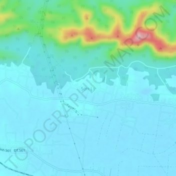
Nom : Carte topographique Sơn Lý, altitude, relief.
Lieu : Sơn Lý, Bố Trạch District, Quang Binh province, Vietnam (17.62033 106.44774 17.66033 106.48774)
Altitude moyenne : 34 m
Altitude minimum : -9 m
Altitude maximum : 223 m
Autres cartes topographiques
Cliquez sur une carte pour visualiser sa topographie, son altitude et son relief.
Phong Nha Town
Vietnam > Quang Binh province > Bố Trạch District
Phong Nha Town, Bố Trạch District, Quảng Bình Province, Vietnam
Altitude moyenne : 66 m