
Carte topographique New Mexico
Carte interactive
Cliquez sur la carte pour afficher l’altitude.
À propos de cette carte
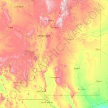
Nom : Carte topographique New Mexico, altitude, relief.
Lieu : New Mexico, United States (31.33221 -109.05022 37.00018 -103.00223)
Altitude moyenne : 1 687 m
Altitude minimum : 744 m
Altitude maximum : 3 830 m
Over four–fifths of New Mexico is higher than 4,000 feet (1,250 meters) above sea level. The average elevation ranges from up to 8,000 feet (2,500 meters) above sea level in the northwest, to less than 4,000 feet in the southeast. The highest point is Wheeler Peak at over 13,160 feet (4,011 meters) in the Sangre de Cristo Mountains, while the lowest is the Red Bluff Reservoir at around 2,840 feet (866 meters), in the southeastern corner of the state.
Autres cartes topographiques
Cliquez sur une carte pour visualiser sa topographie, son altitude et son relief.
Brooklyn
United States > New York > New York
Brooklyn, Kings County, New York, United States
Altitude moyenne : 9 m
Houston
United States > Texas > Harris County
Houston, Harris County, Texas, United States
Altitude moyenne : 25 m
Spokane
United States > Washington > Spokane County
Spokane, Spokane County, Washington, United States
Altitude moyenne : 655 m
College Station
United States > Texas > Brazos County
College Station, Brazos County, Texas, United States
Altitude moyenne : 87 m
New Orleans
United States > Louisiana > Orleans Parish
New Orleans, Orleans Parish, Louisiana, United States
Altitude moyenne : 1 m
Albuquerque
United States > New Mexico > Bernalillo County
Albuquerque, Bernalillo County, New Mexico, United States
Altitude moyenne : 1 688 m
Boulder
United States > Colorado > Boulder County
Boulder, Boulder County, Colorado, United States
Altitude moyenne : 1 785 m
Fort Worth
United States > Texas > Tarrant County
Fort Worth, Tarrant County, Texas, United States
Altitude moyenne : 212 m
Montgomery County
Montgomery County, Texas, United States
Altitude moyenne : 69 m
Hillsborough County
Hillsborough County, Florida, United States
Altitude moyenne : 20 m
Madison
United States > Wisconsin > Dane County
Madison, Dane County, Wisconsin, United States
Altitude moyenne : 284 m
Corpus Christi
United States > Texas > Nueces County
Corpus Christi, Nueces County, Texas, United States
Altitude moyenne : 8 m
Charlotte County
Charlotte County, Florida, United States
Altitude moyenne : 10 m
New Hanover County
United States > North Carolina
New Hanover County, North Carolina, United States
Altitude moyenne : 4 m
Lexington
United States > Kentucky > Lexington
Lexington, Fayette County, Kentucky, 40508, United States
Altitude moyenne : 285 m
Indianapolis
United States > Indiana > Indianapolis
Indianapolis, Marion County, Indiana, 46204, United States
Altitude moyenne : 241 m
Coeur d'Alene
United States > Idaho > Kootenai County
Coeur d'Alene, Kootenai County, Idaho, United States
Altitude moyenne : 719 m
Black Hills
United States > South Dakota > Pennington County
Black Hills, Pennington County, South Dakota, United States
Altitude moyenne : 1 894 m
Greenwich
United States > Connecticut > Western Connecticut Planning Region
Greenwich, Western Connecticut Planning Region, Connecticut, United States
Altitude moyenne : 57 m