
Carte topographique Coeur d'Alene
Carte interactive
Cliquez sur la carte pour afficher l’altitude.
À propos de cette carte
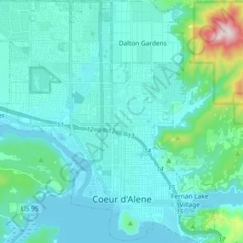
Nom : Carte topographique Coeur d'Alene, altitude, relief.
Lieu : Coeur d'Alene, Kootenai County, Idaho, United States (47.65877 -116.85290 47.74484 -116.73145)
Altitude moyenne : 719 m
Altitude minimum : 644 m
Altitude maximum : 1 254 m
The city is located on the north shore of Lake Coeur d'Alene, near the outlet of the Spokane River, and is in the Northern Rockies ecoregion. Lake Coeur d'Alene is a natural dam-controlled lake that is 25 miles (40 km) long and 1 mile (1.6 km) to 3 miles (4.8 km) wide and fed by the Coeur d'Alene and Saint Joe rivers. Although the Post Falls Dam on the Spokane River near Post Falls controls the lake levels, the lake is usually kept at natural levels from January to June. To the immediate southeast is Fernan Lake and to the northeast of the city is Hayden Lake and even further northeast in northern Kootenai County is Lake Pend Oreille, which is among the largest and deepest natural lakes in the western United States with a surface area of 85,960 acres (347.9 km2) and maximum depth of 1,152 feet (351 m). These lakes, like others in the Spokane Valley and Rathdrum Prairie, were formed by the Missoula Floods, which ended 12,000 to 15,000 years ago. The Coeur d'Alene Mountains of the Bitterroot Range rise to the east of the city to a maximum elevation of 7,352 feet (2,241 m) at Cherry Peak.
Autres cartes topographiques
Cliquez sur une carte pour visualiser sa topographie, son altitude et son relief.
Bayview
United States > Idaho > Kootenai County
Bayview, Kootenai County, Idaho, United States
Altitude moyenne : 733 m
Athol
United States > Idaho > Kootenai County
Athol, Kootenai County, Idaho, United States
Altitude moyenne : 733 m
Post Falls
United States > Idaho > Kootenai County
Post Falls, Kootenai County, Idaho, 83854, United States
Altitude moyenne : 710 m
Hayden
United States > Idaho > Kootenai County
Hayden, Kootenai County, Idaho, 83835, United States
Altitude moyenne : 717 m
Rathdrum
United States > Idaho > Kootenai County
Rathdrum, Kootenai County, Idaho, 83858, United States
Altitude moyenne : 701 m