
Carte topographique Colorado
Carte interactive
Cliquez sur la carte pour afficher l’altitude.
À propos de cette carte
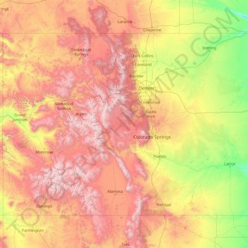
Nom : Carte topographique Colorado, altitude, relief.
Lieu : Colorado, United States (36.99252 -109.06019 41.00340 -102.04159)
Altitude moyenne : 2 060 m
Altitude minimum : 1 020 m
Altitude maximum : 4 379 m
Thirty days later on February 28, 1861, outgoing U.S. President James Buchanan signed an Act of Congress organizing the free Territory of Colorado. The original boundaries of Colorado remain unchanged except for government survey amendments. The name Colorado was chosen because it was commonly believed that the Colorado River originated in the territory. In 1776, Spanish priest Silvestre Vélez de Escalante recorded that Native Americans in the area knew the river as el Rio Colorado for the red-brown silt that the river carried from the mountains. In 1859, a U.S. Army topographic expedition led by Captain John Macomb located the confluence of the Green River with the Grand River in what is now Canyonlands National Park in Utah. The Macomb party designated the confluence as the source of the Colorado River.
Autres cartes topographiques
Cliquez sur une carte pour visualiser sa topographie, son altitude et son relief.
Houston
United States > Texas > Harris County
Houston, Harris County, Texas, United States
Altitude moyenne : 25 m
Spokane
United States > Washington > Spokane County
Spokane, Spokane County, Washington, United States
Altitude moyenne : 655 m
College Station
United States > Texas > Brazos County
College Station, Brazos County, Texas, United States
Altitude moyenne : 87 m
Brooklyn
United States > New York > New York
Brooklyn, Kings County, New York, United States
Altitude moyenne : 9 m
Hillsborough County
Hillsborough County, Florida, United States
Altitude moyenne : 20 m
New Orleans
United States > Louisiana > Orleans Parish
New Orleans, Orleans Parish, Louisiana, United States
Altitude moyenne : 1 m
Montgomery County
Montgomery County, Texas, United States
Altitude moyenne : 69 m
Charlotte County
Charlotte County, Florida, United States
Altitude moyenne : 10 m
Madison
United States > Wisconsin > Dane County
Madison, Dane County, Wisconsin, United States
Altitude moyenne : 284 m
Black Hills
United States > South Dakota > Pennington County
Black Hills, Pennington County, South Dakota, United States
Altitude moyenne : 1 894 m
Chapel Hill
United States > North Carolina > Orange County
Chapel Hill, Orange County, North Carolina, United States
Altitude moyenne : 126 m
Albuquerque
United States > New Mexico > Bernalillo County
Albuquerque, Bernalillo County, New Mexico, United States
Altitude moyenne : 1 688 m
Corpus Christi
United States > Texas > Nueces County
Corpus Christi, Nueces County, Texas, United States
Altitude moyenne : 8 m
Indianapolis
United States > Indiana > Indianapolis
Indianapolis, Marion County, Indiana, 46204, United States
Altitude moyenne : 241 m
Fort Worth
United States > Texas > Tarrant County
Fort Worth, Tarrant County, Texas, United States
Altitude moyenne : 212 m
Lexington
United States > Kentucky > Lexington
Lexington, Fayette County, Kentucky, 40508, United States
Altitude moyenne : 285 m
Boulder
United States > Colorado > Boulder County
Boulder, Boulder County, Colorado, United States
Altitude moyenne : 1 785 m
Nashville-Davidson
United States > Tennessee > Davidson County
Nashville-Davidson, Davidson County, Middle Tennessee, Tennessee, United States
Altitude moyenne : 184 m
Highlands
United States > North Carolina > Macon County > Highlands
Highlands, Macon County, North Carolina, 28741, United States
Altitude moyenne : 1 090 m