
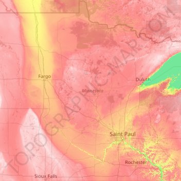
Carte topographique Minnesota
Carte interactive
Cliquez sur la carte pour afficher l’altitude.
À propos de cette carte
Nom : Carte topographique Minnesota, altitude, relief.
Lieu : Minnesota, United States (43.49943 -97.23926 49.38447 -89.48339)
Altitude moyenne : 378 m
Altitude minimum : 176 m
Altitude maximum : 678 m
The state's high point is Eagle Mountain at 2,301 feet (701 m), which is only 13 miles (21 km) away from the low point of 601 feet (183 m) at the shore of Lake Superior. Notwithstanding dramatic local differences in elevation, much of the state is a gently rolling peneplain.
Autres cartes topographiques
Cliquez sur une carte pour visualiser sa topographie, son altitude et son relief.
Houston
United States > Texas > Harris County
Houston, Harris County, Texas, United States
Altitude moyenne : 25 m
Spokane
United States > Washington > Spokane County
Spokane, Spokane County, Washington, United States
Altitude moyenne : 655 m
Brooklyn
United States > New York > New York
Brooklyn, Kings County, New York, United States
Altitude moyenne : 9 m
New Orleans
United States > Louisiana > Orleans Parish
New Orleans, Orleans Parish, Louisiana, United States
Altitude moyenne : 1 m
College Station
United States > Texas > Brazos County
College Station, Brazos County, Texas, United States
Altitude moyenne : 87 m
Montgomery County
Montgomery County, Texas, United States
Altitude moyenne : 69 m
Charlotte County
Charlotte County, Florida, United States
Altitude moyenne : 10 m
Hillsborough County
Hillsborough County, Florida, United States
Altitude moyenne : 20 m
Madison
United States > Wisconsin > Dane County
Madison, Dane County, Wisconsin, United States
Altitude moyenne : 284 m
Black Hills
United States > South Dakota > Pennington County
Black Hills, Pennington County, South Dakota, United States
Altitude moyenne : 1 894 m
Chapel Hill
United States > North Carolina > Orange County
Chapel Hill, Orange County, North Carolina, United States
Altitude moyenne : 126 m
Corpus Christi
United States > Texas > Nueces County
Corpus Christi, Nueces County, Texas, United States
Altitude moyenne : 8 m
Indianapolis
United States > Indiana > Indianapolis
Indianapolis, Marion County, Indiana, 46204, United States
Altitude moyenne : 241 m
Fort Worth
United States > Texas > Tarrant County
Fort Worth, Tarrant County, Texas, United States
Altitude moyenne : 212 m
Lexington
United States > Kentucky > Lexington
Lexington, Fayette County, Kentucky, 40508, United States
Altitude moyenne : 285 m
Boulder
United States > Colorado > Boulder County
Boulder, Boulder County, Colorado, United States
Altitude moyenne : 1 785 m
Nashville-Davidson
United States > Tennessee > Davidson County
Nashville-Davidson, Davidson County, Middle Tennessee, Tennessee, United States
Altitude moyenne : 184 m
Highlands
United States > North Carolina > Macon County > Highlands
Highlands, Macon County, North Carolina, 28741, United States
Altitude moyenne : 1 090 m
York County
United States > South Carolina
York County, South Carolina, United States
Altitude moyenne : 193 m