
Carte topographique Sládkovičovo
Carte interactive
Cliquez sur la carte pour afficher l’altitude.
À propos de cette carte
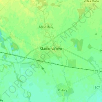
Nom : Carte topographique Sládkovičovo, altitude, relief.
Altitude moyenne : 120 m
Altitude minimum : 114 m
Altitude maximum : 127 m
Autres cartes topographiques
Cliquez sur une carte pour visualiser sa topographie, son altitude et son relief.
Šintava
Slovakia > Region of Trnava > District of Galanta
Šintava, District of Galanta, Region of Trnava, Western Slovakia, 925 51, Slovakia
Altitude moyenne : 138 m
Sereď
Slovakia > Region of Trnava > District of Galanta
Sereď, District of Galanta, Region of Trnava, Western Slovakia, 926 01, Slovakia
Altitude moyenne : 132 m