
Carte topographique Sereď
Carte interactive
Cliquez sur la carte pour afficher l’altitude.
À propos de cette carte
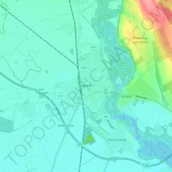
Nom : Carte topographique Sereď, altitude, relief.
Altitude moyenne : 132 m
Altitude minimum : 117 m
Altitude maximum : 204 m
Sereď lies at an altitude of 129 metres (423 ft) above sea level and covers an area of 30.454 square kilometres (11.8 sq mi). It is located in the Danubian Lowland on the Váh river, around 20 kilometres (12 mi) south-east of Trnava, 33 kilometres (21 mi) west of Nitra and around 55 kilometres (34 mi) east from Bratislava. The closest mountain ranges are the Little Carpathians to the west and Považský Inovec to the north.
Autres cartes topographiques
Cliquez sur une carte pour visualiser sa topographie, son altitude et son relief.
Sládkovičovo
Slovakia > Region of Trnava > District of Galanta
Sládkovičovo, District of Galanta, Region of Trnava, Western Slovakia, 925 21, Slovakia
Altitude moyenne : 120 m
Šintava
Slovakia > Region of Trnava > District of Galanta
Šintava, District of Galanta, Region of Trnava, Western Slovakia, 925 51, Slovakia
Altitude moyenne : 138 m