
Carte topographique Šintava
Carte interactive
Cliquez sur la carte pour afficher l’altitude.
À propos de cette carte
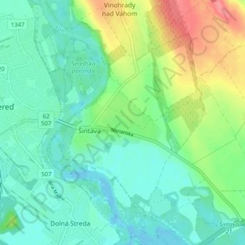
Nom : Carte topographique Šintava, altitude, relief.
Altitude moyenne : 138 m
Altitude minimum : 117 m
Altitude maximum : 188 m
The municipality lies at an elevation of 139 metres and covers an area of 11.565 km². It has a population of about 1719 people.
Autres cartes topographiques
Cliquez sur une carte pour visualiser sa topographie, son altitude et son relief.
Sládkovičovo
Slovakia > Region of Trnava > District of Galanta
Sládkovičovo, District of Galanta, Region of Trnava, Western Slovakia, 925 21, Slovakia
Altitude moyenne : 120 m
Sereď
Slovakia > Region of Trnava > District of Galanta
Sereď, District of Galanta, Region of Trnava, Western Slovakia, 926 01, Slovakia
Altitude moyenne : 132 m