
Carte topographique Yungay
Carte interactive
Cliquez sur la carte pour afficher l’altitude.
À propos de cette carte
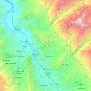
Nom : Carte topographique Yungay, altitude, relief.
Lieu : Yungay, Province of Yungay, Ancash, Peru (-9.17868 -77.78294 -8.99381 -77.57379)
Altitude moyenne : 3 365 m
Altitude minimum : 2 079 m
Altitude maximum : 6 363 m
The Cordillera Blanca traverses the province. Waskaran, the highest elevation of Peru, lies on the border to the Carhuaz Province. Other mountains are listed below:
Autres cartes topographiques
Cliquez sur une carte pour visualiser sa topographie, son altitude et son relief.
Laguna Palococha
Laguna Palococha, AN-110, Ticapampa, Province of Recuay, Ancash, Peru
Altitude moyenne : 3 750 m
Laguna Palococha
Laguna Palococha, AN-110, Ticapampa, Province of Recuay, Ancash, Peru
Altitude moyenne : 3 765 m
Independencia
Peru > Ancash > Independencia
Independencia, Huaraz, Ancash, Peru
Altitude moyenne : 4 096 m
Province of Recuay
Province of Recuay, Cátac, Recuay, Ancash, Peru
Altitude moyenne : 4 232 m
Alpamayo
Peru > Ancash > Santa Cruz
Alpamayo, Santa Cruz, Huaylas, Ancash, Peru
Altitude moyenne : 5 210 m
Laguna Palococha
Laguna Palococha, AN-110, Ticapampa, Recuay, Ancash, Peru
Altitude moyenne : 3 765 m