
Carte topographique Province of Carhuaz
Carte interactive
Cliquez sur la carte pour afficher l’altitude.
À propos de cette carte
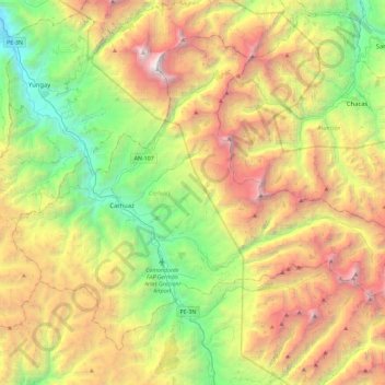
Nom : Carte topographique Province of Carhuaz, altitude, relief.
Lieu : Province of Carhuaz, Ancash, Peru (-9.45280 -77.77670 -9.08191 -77.31813)
Altitude moyenne : 4 038 m
Altitude minimum : 2 248 m
Altitude maximum : 6 726 m
Autres cartes topographiques
Cliquez sur une carte pour visualiser sa topographie, son altitude et son relief.
Laguna Palococha
Laguna Palococha, AN-110, Ticapampa, Province of Recuay, Ancash, Peru
Altitude moyenne : 3 750 m
Laguna Palococha
Laguna Palococha, AN-110, Ticapampa, Province of Recuay, Ancash, Peru
Altitude moyenne : 3 765 m
Independencia
Peru > Ancash > Independencia
Independencia, Huaraz, Ancash, Peru
Altitude moyenne : 4 096 m
Province of Recuay
Province of Recuay, Cátac, Recuay, Ancash, Peru
Altitude moyenne : 4 232 m
Alpamayo
Peru > Ancash > Santa Cruz
Alpamayo, Santa Cruz, Huaylas, Ancash, Peru
Altitude moyenne : 5 210 m
Laguna Palococha
Laguna Palococha, AN-110, Ticapampa, Recuay, Ancash, Peru
Altitude moyenne : 3 765 m