
Carte topographique Huaylas
Carte interactive
Cliquez sur la carte pour afficher l’altitude.
À propos de cette carte
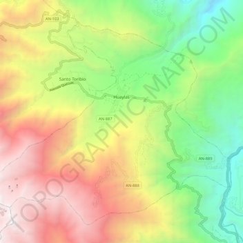
Nom : Carte topographique Huaylas, altitude, relief.
Lieu : Huaylas, Ancash, Pérou (-8.92747 -77.95099 -8.83857 -77.84489)
Altitude moyenne : 3 145 m
Altitude minimum : 1 712 m
Altitude maximum : 4 898 m
Autres cartes topographiques
Cliquez sur une carte pour visualiser sa topographie, son altitude et son relief.
Laguna Churup
Pérou > Ancash > Independencia
Le lac Churup (laguna Churup, en espagnol) est situé à une altitude de 4 450 mètres dans la montagne enneigée Churup dans le Parc national du Huascarán près de la ville de Huaraz au Pérou. Le lac est alimenté par le glacier de la montagne Churup et se déverse dans la vallée Quillcayhuanca pour former…
Altitude moyenne : 4 524 m
Cordillère américaine
Pérou > Ancash > San Miguel de Aco
Cette vaste cordillère culmine en Argentine à 6 962 mètres d'altitude à l'Aconcagua.
Altitude moyenne : 4 791 m