
Carte topographique Enping City
Carte interactive
Cliquez sur la carte pour afficher l’altitude.
À propos de cette carte
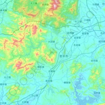
Nom : Carte topographique Enping City, altitude, relief.
Lieu : Enping City, Jiangmen City, Guangdong, PRC (21.91134 111.99921 22.49763 112.52528)
Altitude moyenne : 139 m
Altitude minimum : -5 m
Altitude maximum : 1 171 m
Autres cartes topographiques
Cliquez sur une carte pour visualiser sa topographie, son altitude et son relief.
Xiasha
PRC > Guangdong > Shenzhen City > Xiasha
Xiasha, Futian District, Shenzhen City, Guangdong, 518000, PRC
Altitude moyenne : 18 m
Guangzhou City
PRC > Guangdong > Guangzhou City
Haizhu, Haizhu District, Guangzhou City, Guangdong, 510310, PRC
Altitude moyenne : 20 m
Conghua District
PRC > Guangdong > Guangzhou City
Conghua District, Guangzhou City, Guangdong, PRC
Altitude moyenne : 184 m
Guangzhou City
PRC > Guangdong > Guangzhou City
Nansha, Nansha District, Guangzhou City, Guangdong, 511457, PRC
Altitude moyenne : 4 m
Bao'an District
PRC > Guangdong > Shenzhen City
Bao'an District, Shenzhen City, Guangdong, 518100, PRC
Altitude moyenne : 39 m
Futian District
PRC > Guangdong > Shenzhen City
Futian District, Shenzhen City, Guangdong, 518000, PRC
Altitude moyenne : 49 m
Sham Chun River
PRC > Guangdong > Shenzhen City
Sham Chun River, Huangbei, Luohu District, Shenzhen City, Guangdong, 518000, PRC
Altitude moyenne : 18 m
Guangzhou City
PRC > Guangdong > Guangzhou City
Pānyú, Panyu District, Guangzhou City, Guangdong, PRC
Altitude moyenne : 6 m