
Carte topographique Conghua District
Carte interactive
Cliquez sur la carte pour afficher l’altitude.
À propos de cette carte
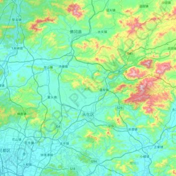
Nom : Carte topographique Conghua District, altitude, relief.
Lieu : Conghua District, Guangzhou City, Guangdong, PRC (23.37460 113.28063 23.93608 114.05008)
Altitude moyenne : 184 m
Altitude minimum : -1 m
Altitude maximum : 1 165 m
Autres cartes topographiques
Cliquez sur une carte pour visualiser sa topographie, son altitude et son relief.
Guangzhou City
PRC > Guangdong > Guangzhou City
Haizhu, Haizhu District, Guangzhou City, Guangdong, 510310, PRC
Altitude moyenne : 20 m
Guangzhou City
PRC > Guangdong > Guangzhou City
Nansha, Nansha District, Guangzhou City, Guangdong, 511457, PRC
Altitude moyenne : 4 m
Guangzhou City
PRC > Guangdong > Guangzhou City
Pānyú, Panyu District, Guangzhou City, Guangdong, PRC
Altitude moyenne : 6 m