
Carte topographique Futian District
Carte interactive
Cliquez sur la carte pour afficher l’altitude.
À propos de cette carte
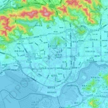
Nom : Carte topographique Futian District, altitude, relief.
Lieu : Futian District, Shenzhen City, Guangdong, 518000, PRC (22.50224 113.98526 22.58993 114.09994)
Altitude moyenne : 49 m
Altitude minimum : -5 m
Altitude maximum : 361 m
Autres cartes topographiques
Cliquez sur une carte pour visualiser sa topographie, son altitude et son relief.
Xiasha
PRC > Guangdong > Shenzhen City > Xiasha
Xiasha, Futian District, Shenzhen City, Guangdong, 518000, PRC
Altitude moyenne : 18 m
Bao'an District
PRC > Guangdong > Shenzhen City
Bao'an District, Shenzhen City, Guangdong, 518100, PRC
Altitude moyenne : 39 m
Sham Chun River
PRC > Guangdong > Shenzhen City
Sham Chun River, Huangbei, Luohu District, Shenzhen City, Guangdong, 518000, PRC
Altitude moyenne : 18 m