
Carte topographique Bartlett
Carte interactive
Cliquez sur la carte pour afficher l’altitude.
À propos de cette carte
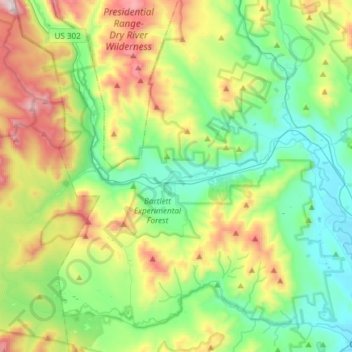
Nom : Carte topographique Bartlett, altitude, relief.
Lieu : Bartlett, Carroll County, New Hampshire, United States (44.02223 -71.38260 44.13978 -71.08385)
Altitude moyenne : 493 m
Altitude minimum : 137 m
Altitude maximum : 1 285 m
According to the United States Census Bureau, the town has a total area of 75.3 square miles (195 km2), of which 74.9 square miles (194 km2) is land and 0.4 square miles (1.0 km2), or 0.57%, is water. Bartlett is drained by the Saco and Ellis rivers. The highest point in Bartlett is Mount Tremont, elevation 3,371 feet (1,027 m) above sea level. Mount Parker, elevation 3,004 ft (916 m), is in the north, and Bear Mountain, elevation 3,200 ft (980 m), is on the southern boundary. Bartlett lies fully within the Saco River watershed.
Autres cartes topographiques
Cliquez sur une carte pour visualiser sa topographie, son altitude et son relief.
Eaton
United States > New Hampshire > Carroll County
Eaton, Carroll County, New Hampshire, 03832, United States
Altitude moyenne : 262 m
Ossipee
United States > New Hampshire > Carroll County
Ossipee, Carroll County, New Hampshire, United States
Altitude moyenne : 217 m
Sandwich
United States > New Hampshire > Carroll County
Sandwich, Carroll County, New Hampshire, 03259, United States
Altitude moyenne : 373 m
Flat Mountain
United States > New Hampshire > Carroll County > Sandwich
Flat Mountain, Sandwich, Carroll County, New Hampshire, United States
Altitude moyenne : 629 m
Moultonborough
United States > New Hampshire > Carroll County
Moultonborough, Carroll County, New Hampshire, United States
Altitude moyenne : 243 m
Albany
United States > New Hampshire > Carroll County > Albany
Albany, Carroll County, New Hampshire, United States
Altitude moyenne : 276 m
Bayle Mountain
United States > New Hampshire > Carroll County > Ossipee
Bayle Mountain, Ossipee, Carroll County, New Hampshire, United States
Altitude moyenne : 405 m
Whitton Pond
United States > New Hampshire > Carroll County > Albany
Whitton Pond, Albany, Carroll County, New Hampshire, United States
Altitude moyenne : 273 m
Wolfeboro
United States > New Hampshire > Carroll County
Wolfeboro, Carroll County, New Hampshire, United States
Altitude moyenne : 213 m
Albany
United States > New Hampshire > Carroll County > Albany
Albany, Carroll County, New Hampshire, 03818, United States
Altitude moyenne : 409 m
Tamworth
United States > New Hampshire > Carroll County > Tamworth
Tamworth, Carroll County, New Hampshire, United States
Altitude moyenne : 263 m
Conway
United States > New Hampshire > Carroll County
Conway, Carroll County, New Hampshire, United States
Altitude moyenne : 256 m
Freedom
United States > New Hampshire > Carroll County
Freedom, Carroll County, New Hampshire, 03836, United States
Altitude moyenne : 224 m