
Carte topographique Ossipee
Carte interactive
Cliquez sur la carte pour afficher l’altitude.
À propos de cette carte
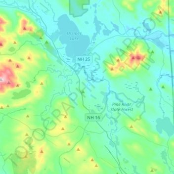
Nom : Carte topographique Ossipee, altitude, relief.
Lieu : Ossipee, Carroll County, New Hampshire, United States (43.63642 -71.27994 43.83284 -71.01360)
Altitude moyenne : 217 m
Altitude minimum : 114 m
Altitude maximum : 715 m
The two primary settlements in town are Center Ossipee, located near the southern junction of routes 16 and 25, and Ossipee Corner (shown as "Ossipee" on topographic maps), located 5 miles (8 km) south of Center Ossipee at the junction of routes 28 and 171 and close to Route 16. Other villages include West Ossipee, at the northern junction of routes 16 and 25 near the border with Tamworth; Moultonville, directly west of Center Ossipee; and Water Village, along Route 171 near the border with Tuftonboro.
Autres cartes topographiques
Cliquez sur une carte pour visualiser sa topographie, son altitude et son relief.
Eaton
United States > New Hampshire > Carroll County
Eaton, Carroll County, New Hampshire, 03832, United States
Altitude moyenne : 262 m
Sandwich
United States > New Hampshire > Carroll County
Sandwich, Carroll County, New Hampshire, 03259, United States
Altitude moyenne : 373 m
Flat Mountain
United States > New Hampshire > Carroll County > Sandwich
Flat Mountain, Sandwich, Carroll County, New Hampshire, United States
Altitude moyenne : 629 m
Moultonborough
United States > New Hampshire > Carroll County
Moultonborough, Carroll County, New Hampshire, United States
Altitude moyenne : 243 m
Albany
United States > New Hampshire > Carroll County > Albany
Albany, Carroll County, New Hampshire, United States
Altitude moyenne : 276 m
Bayle Mountain
United States > New Hampshire > Carroll County > Ossipee
Bayle Mountain, Ossipee, Carroll County, New Hampshire, United States
Altitude moyenne : 405 m
Bartlett
United States > New Hampshire > Carroll County
Bartlett, Carroll County, New Hampshire, United States
Altitude moyenne : 493 m
Whitton Pond
United States > New Hampshire > Carroll County > Albany
Whitton Pond, Albany, Carroll County, New Hampshire, United States
Altitude moyenne : 273 m
Wolfeboro
United States > New Hampshire > Carroll County
Wolfeboro, Carroll County, New Hampshire, United States
Altitude moyenne : 213 m
Albany
United States > New Hampshire > Carroll County > Albany
Albany, Carroll County, New Hampshire, 03818, United States
Altitude moyenne : 409 m
Tamworth
United States > New Hampshire > Carroll County > Tamworth
Tamworth, Carroll County, New Hampshire, United States
Altitude moyenne : 263 m
Conway
United States > New Hampshire > Carroll County
Conway, Carroll County, New Hampshire, United States
Altitude moyenne : 256 m
Freedom
United States > New Hampshire > Carroll County
Freedom, Carroll County, New Hampshire, 03836, United States
Altitude moyenne : 224 m