
Carte topographique Sandwich
Carte interactive
Cliquez sur la carte pour afficher l’altitude.
À propos de cette carte
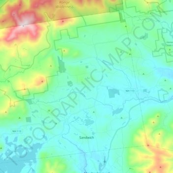
Nom : Carte topographique Sandwich, altitude, relief.
Altitude moyenne : 373 m
Altitude minimum : 155 m
Altitude maximum : 1 200 m
According to the United States Census Bureau, the town has a total area of 94.1 square miles (243.8 km2), of which 90.9 square miles (235.4 km2) are land and 3.3 square miles (8.5 km2) are water, comprising 3.47% of the town. Sandwich is drained to the east by the Bearcamp and Cold rivers, to the northwest by the Beebe River, to the southwest by Squam Lake, and to the south by the Red Hill River. The Bearcamp and Cold rivers are part of the Saco River watershed, draining east into Maine, while the remainder of the town is part of the Merrimack River watershed, draining south to Massachusetts. Mount Israel, elevation 2,630 feet (802 m) above sea level, is at the center. Part of the Squam Mountains is in the west. Part of the Sandwich Range is in the north, including the 3,993-foot (1,217 m) Sandwich Mountain (also known as Sandwich Dome), the highest point in town as well as in Carroll County.
Autres cartes topographiques
Cliquez sur une carte pour visualiser sa topographie, son altitude et son relief.
Eaton
United States > New Hampshire > Carroll County
Eaton, Carroll County, New Hampshire, 03832, United States
Altitude moyenne : 262 m
Ossipee
United States > New Hampshire > Carroll County
Ossipee, Carroll County, New Hampshire, United States
Altitude moyenne : 217 m
Flat Mountain
United States > New Hampshire > Carroll County > Sandwich
Flat Mountain, Sandwich, Carroll County, New Hampshire, United States
Altitude moyenne : 629 m
Moultonborough
United States > New Hampshire > Carroll County
Moultonborough, Carroll County, New Hampshire, United States
Altitude moyenne : 243 m
Albany
United States > New Hampshire > Carroll County > Albany
Albany, Carroll County, New Hampshire, United States
Altitude moyenne : 276 m
Bayle Mountain
United States > New Hampshire > Carroll County > Ossipee
Bayle Mountain, Ossipee, Carroll County, New Hampshire, United States
Altitude moyenne : 405 m
Bartlett
United States > New Hampshire > Carroll County
Bartlett, Carroll County, New Hampshire, United States
Altitude moyenne : 493 m
Whitton Pond
United States > New Hampshire > Carroll County > Albany
Whitton Pond, Albany, Carroll County, New Hampshire, United States
Altitude moyenne : 273 m
Wolfeboro
United States > New Hampshire > Carroll County
Wolfeboro, Carroll County, New Hampshire, United States
Altitude moyenne : 213 m
Albany
United States > New Hampshire > Carroll County > Albany
Albany, Carroll County, New Hampshire, 03818, United States
Altitude moyenne : 409 m
Tamworth
United States > New Hampshire > Carroll County > Tamworth
Tamworth, Carroll County, New Hampshire, United States
Altitude moyenne : 263 m
Conway
United States > New Hampshire > Carroll County
Conway, Carroll County, New Hampshire, United States
Altitude moyenne : 256 m
Freedom
United States > New Hampshire > Carroll County
Freedom, Carroll County, New Hampshire, 03836, United States
Altitude moyenne : 224 m