
Carte topographique Leicestershire
Carte interactive
Cliquez sur la carte pour afficher l’altitude.
À propos de cette carte
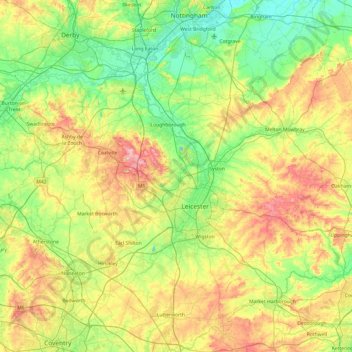
Nom : Carte topographique Leicestershire, altitude, relief.
Lieu : Leicestershire, England, United Kingdom (52.39217 -1.59755 52.97766 -0.66411)
Altitude moyenne : 98 m
Altitude minimum : 16 m
Altitude maximum : 269 m
A large part of the north-west of the county, around Coalville, forms part of the new National Forest area extending into Derbyshire and Staffordshire. The highest point of the county is Bardon Hill at 278 m (912 ft), which is also a Marilyn; with other hilly/upland areas of c. 150–200 metres (490–660 ft) and above in nearby Charnwood Forest and also to the east of the county around Launde Abbey. The lowest point, at an altitude of about 20 metres (66 ft), is located at the county's northernmost tip close to Bottesford where the River Devon flowing through the Vale of Belvoir leaves Leicestershire and enters Nottinghamshire. This results in an altitude differential (AΔ|vertical) of around 257.5 metres (845 ft) and a mean altitude of 148.75 metres (488.0 ft).
Autres cartes topographiques
Cliquez sur une carte pour visualiser sa topographie, son altitude et son relief.
Shepshed
United Kingdom > England > Leicestershire > Charnwood
Shepshed, Charnwood, Leicestershire, England, United Kingdom
Altitude moyenne : 111 m
Hemington
United Kingdom > England > Leicestershire > North West Leicestershire
Hemington, North West Leicestershire, Leicestershire, England, DE74 2TJ, United Kingdom
Altitude moyenne : 51 m
Mammoth Lake
United Kingdom > England > Leicestershire > Borough of Charnwood > Thurmaston
Mammoth Lake, Thurmaston, Borough of Charnwood, Leicestershire, England, United Kingdom
Altitude moyenne : 58 m
Harborough District
United Kingdom > England > Leicestershire
Harborough District, Leicestershire, England, United Kingdom
Altitude moyenne : 116 m
Braunstone Town
United Kingdom > England > Leicestershire > Braunstone Town
Braunstone Town, Blaby, Leicestershire, England, LE3 2SX, United Kingdom
Altitude moyenne : 78 m
Lutterworth
United Kingdom > England > Leicestershire > Harborough > Lutterworth
Lutterworth, Harborough, Leicestershire, East Midlands, England, United Kingdom
Altitude moyenne : 125 m
Ashby-de-la-Zouch
United Kingdom > England > Leicestershire > North West Leicestershire > Ashby-de-la-Zouch
Ashby-de-la-Zouch, North West Leicestershire, Leicestershire, East Midlands, England, United Kingdom
Altitude moyenne : 132 m
Desford
United Kingdom > England > Leicestershire > Hinckley and Bosworth
Desford, Hinckley and Bosworth, Leicestershire, England, United Kingdom
Altitude moyenne : 115 m
Leicester
United Kingdom > England > Leicestershire
Leicester, Leicestershire, England, LE1 5YA, United Kingdom
Altitude moyenne : 109 m
Sileby
United Kingdom > England > Leicestershire > Charnwood
Sileby, Charnwood, Leicestershire, England, United Kingdom
Altitude moyenne : 69 m
Wanlip
United Kingdom > England > Leicestershire > Borough of Charnwood
Wanlip, Borough of Charnwood, Leicestershire, England, LE7 4PH, United Kingdom
Altitude moyenne : 61 m
Kibworth Harcourt
United Kingdom > England > Leicestershire > Harborough District
Kibworth Beauchamp, Kibworth Harcourt, Harborough District, Leicestershire, England, United Kingdom
Altitude moyenne : 113 m
Coalville
United Kingdom > England > Leicestershire > North West Leicestershire
Coalville, North West Leicestershire, Leicestershire, England, LE67 3DW, United Kingdom
Altitude moyenne : 149 m
Burrough on the Hill
United Kingdom > England > Leicestershire > Borough of Melton
Burrough on the Hill, Borough of Melton, Leicestershire, England, LE14 2JL, United Kingdom
Altitude moyenne : 153 m
Great Dalby
United Kingdom > England > Leicestershire > Borough of Melton
Great Dalby, Borough of Melton, Leicestershire, England, LE14 2EN, United Kingdom
Altitude moyenne : 121 m
Loughborough
United Kingdom > England > Leicestershire > Charnwood
Loughborough, Charnwood, Leicestershire, England, LE11 5BJ, United Kingdom
Altitude moyenne : 61 m