
Carte topographique Triệu Phong District
Carte interactive
Cliquez sur la carte pour afficher l’altitude.
À propos de cette carte
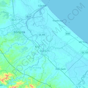
Nom : Carte topographique Triệu Phong District, altitude, relief.
Lieu : Triệu Phong District, Quang Tri province, Vietnam (16.64502 107.00015 16.90846 107.30892)
Altitude moyenne : 15 m
Altitude minimum : -3 m
Altitude maximum : 322 m
Ái Tử Township is the economic, socio-cultural center of the district, which is 7 km south of Đông Hà City and 6 km north of Quảng Trị Town. Trieu Phong is a district consisting mainly of a coastal plain with a small number of low hills in the communes of Triệu Thượng and Triệu Ái in the west, the eastern topography of the district is sand dunes and white sand dunes. The last section of Thạch Hãn River flows to Cửa Việt estuary located in the district.
Autres cartes topographiques
Cliquez sur une carte pour visualiser sa topographie, son altitude et son relief.
Bến Quan
Vietnam > Quang Tri province > Vĩnh Linh District
Bến Quan, Vĩnh Linh District, Quang Tri province, Vietnam
Altitude moyenne : 30 m
An Xuân
Vietnam > Quang Tri province > Gio Linh District
An Xuân, Gio Linh District, Quang Tri province, Vietnam
Altitude moyenne : 10 m
Lương Sơn
Vietnam > Quang Tri province > Hải Lăng District
Lương Sơn, Hải Lăng District, Quang Tri province, Vietnam
Altitude moyenne : 8 m
Diên Sanh
Vietnam > Quang Tri province > Hải Lăng District
Diên Sanh, Hải Lăng District, Quang Tri province, Vietnam
Altitude moyenne : 9 m
Khe Sanh
Vietnam > Quang Tri province > Hướng Hóa District > Khe Sanh
Khe Sanh, Hướng Hóa District, Quang Tri province, Vietnam
Altitude moyenne : 386 m
Gio Linh District
Gio Linh District, Quang Tri province, 47000, Vietnam
Altitude moyenne : 50 m
Tân Lập
Vietnam > Quang Tri province > Tân Lập
Tân Lập, Hướng Hóa District, Quang Tri province, Vietnam
Altitude moyenne : 344 m
Quang Tri Town
Quang Tri Town, Quang Tri province, Vietnam
Altitude moyenne : 29 m
Đakrông District
Đakrông District, Quang Tri province, Vietnam
Altitude moyenne : 373 m