
Carte topographique Gio Linh District
Carte interactive
Cliquez sur la carte pour afficher l’altitude.
À propos de cette carte
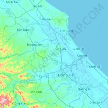
Nom : Carte topographique Gio Linh District, altitude, relief.
Lieu : Gio Linh District, Quang Tri province, 47000, Vietnam (16.80982 106.68583 17.01482 107.19536)
Altitude moyenne : 50 m
Altitude minimum : -2 m
Altitude maximum : 734 m
Autres cartes topographiques
Cliquez sur une carte pour visualiser sa topographie, son altitude et son relief.
Bến Quan
Vietnam > Quang Tri province > Vĩnh Linh District
Bến Quan, Vĩnh Linh District, Quang Tri province, Vietnam
Altitude moyenne : 30 m
An Xuân
Vietnam > Quang Tri province > Gio Linh District
An Xuân, Gio Linh District, Quang Tri province, Vietnam
Altitude moyenne : 10 m
Triệu Phong District
Triệu Phong District, Quang Tri province, Vietnam
Altitude moyenne : 15 m
Lương Sơn
Vietnam > Quang Tri province > Hải Lăng District
Lương Sơn, Hải Lăng District, Quang Tri province, Vietnam
Altitude moyenne : 8 m
Diên Sanh
Vietnam > Quang Tri province > Hải Lăng District
Diên Sanh, Hải Lăng District, Quang Tri province, Vietnam
Altitude moyenne : 9 m
Khe Sanh
Vietnam > Quang Tri province > Hướng Hóa District > Khe Sanh
Khe Sanh, Hướng Hóa District, Quang Tri province, Vietnam
Altitude moyenne : 386 m
Tân Lập
Vietnam > Quang Tri province > Tân Lập
Tân Lập, Hướng Hóa District, Quang Tri province, Vietnam
Altitude moyenne : 344 m
Quang Tri Town
Quang Tri Town, Quang Tri province, Vietnam
Altitude moyenne : 29 m
Đakrông District
Đakrông District, Quang Tri province, Vietnam
Altitude moyenne : 373 m