
Carte topographique Wyoming
Carte interactive
Cliquez sur la carte pour afficher l’altitude.
À propos de cette carte
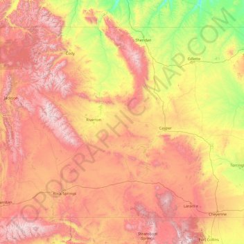
Nom : Carte topographique Wyoming, altitude, relief.
Lieu : Wyoming, United States (40.99482 -111.05527 45.00583 -104.05239)
Altitude moyenne : 1 938 m
Altitude minimum : 916 m
Altitude maximum : 4 047 m
Wyoming's western half is covered mostly by the ranges and rangelands of the Rocky Mountains, while the eastern half of the state is high-elevation prairie called the High Plains. It is drier and windier than the rest of the country, being split between semi-arid and continental climates with greater temperature extremes. Almost half of the land in Wyoming is owned by the federal government, generally protected for public uses. The state ranks 6th by area and fifth by proportion of a state's land owned by the federal government. Federal lands include two national parks (Grand Teton and Yellowstone), two national recreation areas, two national monuments, several national forests, historic sites, fish hatcheries, and wildlife refuges.
Autres cartes topographiques
Cliquez sur une carte pour visualiser sa topographie, son altitude et son relief.
Houston
United States > Texas > Harris County
Houston, Harris County, Texas, United States
Altitude moyenne : 25 m
Montgomery County
Montgomery County, Texas, United States
Altitude moyenne : 69 m
The Woodlands
United States > Texas > Montgomery County
The Woodlands, Montgomery County, Texas, United States
Altitude moyenne : 47 m
Albuquerque
United States > New Mexico > Bernalillo County
Albuquerque, Bernalillo County, New Mexico, United States
Altitude moyenne : 1 688 m
Fort Worth
United States > Texas > Tarrant County
Fort Worth, Tarrant County, Texas, United States
Altitude moyenne : 212 m
Bay Mills
United States > Michigan > Chippewa County
Bay Mills, Bay Mills Township, Chippewa County, Michigan, 49715, United States
Altitude moyenne : 182 m
Brooklyn
United States > New York > New York
Brooklyn, Kings County, New York, United States
Altitude moyenne : 9 m
New Orleans
United States > Louisiana > Orleans Parish
New Orleans, Orleans Parish, Louisiana, United States
Altitude moyenne : 1 m
Georgetown
United States > Texas > Georgetown
Georgetown, Williamson County, Texas, United States
Altitude moyenne : 219 m
Jacksonville
United States > Florida > Duval County
Jacksonville, Duval County, Florida, United States
Altitude moyenne : 10 m
Sequoia National Park
United States > California > Tulare County
Sequoia National Park, Tulare County, California, United States
Altitude moyenne : 2 515 m
Palm Beach County
Palm Beach County, Florida, United States
Altitude moyenne : 5 m
Seattle
United States > Washington > King County
Seattle, King County, Washington, United States
Altitude moyenne : 40 m
Central Valley
United States > California > San Joaquin County
Central Valley, San Joaquin County, California, 95201, United States
Altitude moyenne : -1 m
Buncombe County
United States > North Carolina
Buncombe County, North Carolina, United States
Altitude moyenne : 839 m
Sarasota
United States > Florida > Sarasota County
Sarasota, Sarasota County, Florida, United States
Altitude moyenne : 7 m
Sonoma County
Sonoma County, California, United States
Altitude moyenne : 210 m
Miami-Dade County
Miami-Dade County, Florida, United States
Altitude moyenne : 3 m