
Carte topographique Durgam Cheruvu Secret Lake Park
Carte interactive
Cliquez sur la carte pour afficher l’altitude.
À propos de cette carte
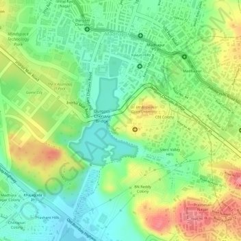
Nom : Carte topographique Durgam Cheruvu Secret Lake Park, altitude, relief.
Altitude moyenne : 579 m
Altitude minimum : 540 m
Altitude maximum : 629 m
Autres cartes topographiques
Cliquez sur une carte pour visualiser sa topographie, son altitude et son relief.
Gopanpally Tank
India > Telangana > Serilingampalle mandal > Hyderabad
Gopanpally Tank, Ward 105 Gachibowli, Greater Hyderabad Municipal Corporation West Zone, Hyderabad, Serilingampalle mandal, Ranga Reddy District, Telangana, India
Altitude moyenne : 577 m
Durgam Cheruvu
India > Telangana > Serilingampalle mandal > Hyderabad
Durgam Cheruvu, Durgam Cheruvu Road, Madhapur, Ward 104 Kondapur, Greater Hyderabad Municipal Corporation West Zone, Hyderabad, Serilingampalle mandal, Ranga Reddy District, Telangana, 996544, India
Altitude moyenne : 577 m
Patel Cheruvu
India > Telangana > Serilingampalle mandal > Hyderabad
Patel Cheruvu, Ward 108 Miyapur, Hyderabad, Serilingampalle mandal, Rangareddy, Telangana, India
Altitude moyenne : 577 m