
Merci de soutenir ce site ❤️
Faire un don
Faire un don
Équipez-vous pour votre prochaine aventure :
En tant que Partenaire Amazon, ce site perçoit une commission sur les achats éligibles sans surcoût pour vous.
Carte topographique Gopanpally Tank
Cliquez sur la carte pour afficher l’altitude.
Merci de soutenir ce site ❤️
Faire un don
Faire un don
Équipez-vous pour votre prochaine aventure :
🥾Bottes de randonnée imperméables - Chaussures robustes adaptées aux dénivelés et aux terrains rocheux
En tant que Partenaire Amazon, ce site perçoit une commission sur les achats éligibles sans surcoût pour vous.
À propos de cette carte
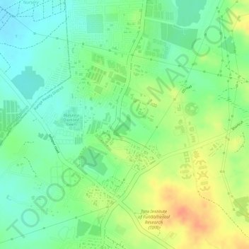
Nom : Carte topographique Gopanpally Tank, altitude, relief.
Altitude moyenne : 577 m
Altitude minimum : 556 m
Altitude maximum : 601 m
Merci de soutenir ce site ❤️
Faire un don
Faire un don
Équipez-vous pour votre prochaine aventure :
En tant que Partenaire Amazon, ce site perçoit une commission sur les achats éligibles sans surcoût pour vous.
Autres cartes topographiques
Cliquez sur une carte pour visualiser sa topographie, son altitude et son relief.
Ward 106 Serilingampally
India > Telangana > Serilingampalle mandal > Hyderabad
Altitude moyenne : 588 m
Durgam Cheruvu Secret Lake Park
India > Telangana > Serilingampalle mandal > Hyderabad
Altitude moyenne : 579 m