Géolocaliser

Carte topographique Patel Cheruvu

Carte interactive

Cliquez sur la carte pour afficher l’altitude.

À propos de cette carte

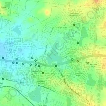
Nom : Carte topographique Patel Cheruvu, altitude, relief.

Lieu : Patel Cheruvu, Ward 108 Miyapur, Hyderabad, Serilingampalle mandal, Rangareddy, Telangana, India (17.49429 78.34901 17.50022 78.35402)

Altitude moyenne : 577 m

Altitude minimum : 560 m

Altitude maximum : 597 m

Autres cartes topographiques

Cliquez sur une carte pour visualiser sa topographie, son altitude et son relief.

Gopanpally Tank

India > Telangana > Serilingampalle mandal > Hyderabad

Gopanpally Tank, Ward 105 Gachibowli, Greater Hyderabad Municipal Corporation West Zone, Hyderabad, Serilingampalle mandal, Ranga Reddy District, Telangana, India

Altitude moyenne : 577 m

Durgam Cheruvu

India > Telangana > Serilingampalle mandal > Hyderabad

Durgam Cheruvu, Durgam Cheruvu Road, Madhapur, Ward 104 Kondapur, Greater Hyderabad Municipal Corporation West Zone, Hyderabad, Serilingampalle mandal, Ranga Reddy District, Telangana, 996544, India

Altitude moyenne : 577 m

Durgam Cheruvu Secret Lake Park

India > Telangana > Serilingampalle mandal > Hyderabad

Durgam Cheruvu Secret Lake Park, CBI Colony, Ward 104 Kondapur, Serilingampalle mandal, Hyderabad, Rangareddy, Telangana, 996544, India

Altitude moyenne : 579 m