
Carte topographique Hokitika
Carte interactive
Cliquez sur la carte pour afficher l’altitude.
À propos de cette carte
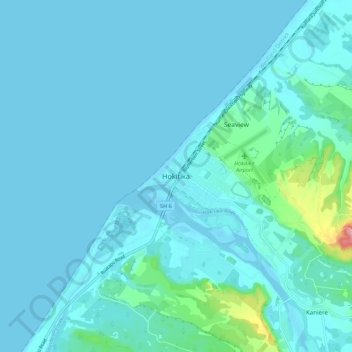
Nom : Carte topographique Hokitika, altitude, relief.
Lieu : Hokitika, Westland District, West Coast, 7810, New Zealand (-42.75789 170.92465 -42.67789 171.00465)
Altitude moyenne : 14 m
Altitude minimum : 0 m
Altitude maximum : 155 m
Autres cartes topographiques
Cliquez sur une carte pour visualiser sa topographie, son altitude et son relief.
Mount Howitt
New Zealand > West Coast > Westland District
Mount Howitt, Westland District, West Coast, New Zealand
Altitude moyenne : 1 577 m
Franz Josef Glacier
New Zealand > West Coast > Westland District
Franz Josef Glacier, Westland District, West Coast, New Zealand
Altitude moyenne : 1 709 m
Perth River
New Zealand > West Coast > Westland District
Perth River, Westland District, West Coast, New Zealand
Altitude moyenne : 918 m
Storm
New Zealand > West Coast > Westland District
Storm, Westland District, West Coast, New Zealand
Altitude moyenne : 1 525 m
Ōkārito
New Zealand > West Coast > Westland District > Ōkārito
Ōkārito, Westland District, West Coast, New Zealand
Altitude moyenne : 25 m