
Carte topographique Clark County
Carte interactive
Cliquez sur la carte pour afficher l’altitude.
À propos de cette carte
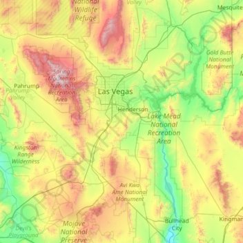
Nom : Carte topographique Clark County, altitude, relief.
Lieu : Clark County, Nevada, United States of America (35.00189 -115.89535 36.85409 -114.04573)
Altitude moyenne : 968 m
Altitude minimum : 149 m
Altitude maximum : 3 536 m
The Colorado River forms the county's southeastern boundary, with Hoover Dam forming Lake Mead along much of its length. The lowest point in the state of Nevada is on the Colorado River just south of Laughlin in Clark County, where it flows out of Nevada into California and Arizona. Greater Las Vegas is a tectonic valley, surrounded by four mountain ranges, with nearby Mount Charleston being the highest elevation at 11,918 ft (3,633 m), located to the northwest. Other than the forests on Mount Charleston, the geography in Clark County is a desert. Creosote bushes are the main native vegetation, and the mountains are mostly rocky with little vegetation. The terrain slopes to the south and east. The county has an area of 8,061 square miles (20,880 km2), of which 7,891 square miles (20,440 km2) is land and 169 square miles (440 km2) (2.1%) is water.
Autres cartes topographiques
Cliquez sur une carte pour visualiser sa topographie, son altitude et son relief.
Pershing County
United States of America > Nevada
Pershing County, Nevada, United States of America
Altitude moyenne : 1 449 m
Lincoln County
United States of America > Nevada
Lincoln County, Nevada, United States of America
Altitude moyenne : 1 639 m
Lander County
United States of America > Nevada
Lander County, Nevada, United States of America
Altitude moyenne : 1 768 m
Mesquite
United States of America > Nevada > Mesquite
Mesquite, Clark County, Nevada, United States of America
Altitude moyenne : 601 m
Whitney
United States of America > Nevada > Whitney
Whitney, Clark County, Nevada, United States of America
Altitude moyenne : 524 m
North Valley
United States of America > Nevada > Reno > North Valley
North Valley, Reno, Washoe County, Nevada, 89512, United States of America
Altitude moyenne : 1 419 m
Jackman
United States of America > Nevada > Jackman
Jackman, Clark County, Nevada, United States of America
Altitude moyenne : 506 m
Elko County
United States of America > Nevada
Elko County, Nevada, United States of America
Altitude moyenne : 1 838 m