
Carte topographique Lincoln County
Carte interactive
Cliquez sur la carte pour afficher l’altitude.
À propos de cette carte
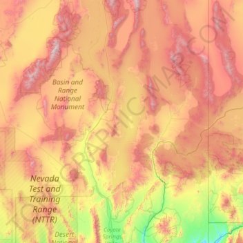
Nom : Carte topographique Lincoln County, altitude, relief.
Lieu : Lincoln County, Nevada, United States of America (36.84208 -115.89755 38.67849 -114.04847)
Altitude moyenne : 1 639 m
Altitude minimum : 571 m
Altitude maximum : 3 391 m
According to the U.S. Census Bureau, the county has a total area of 10,637 square miles (27,550 km2), of which 10,633 square miles (27,540 km2) is land and 3.8 square miles (9.8 km2) (0.04%) is water. While only the third largest county by area in the state of Nevada, it is the seventh-largest county in area in the United States, not including boroughs and census areas in Alaska. The south cliff of Mount Rummel, the summit of which is just north of the county line in by this places side: White Pine County, contains the highest point in Lincoln County at 10,640 feet (3,240 m). The highest independent mountain completely within Lincoln County is Shingle Peak, while the county's most topographically prominent peak is Mormon Peak.
Autres cartes topographiques
Cliquez sur une carte pour visualiser sa topographie, son altitude et son relief.
Pershing County
United States of America > Nevada
Pershing County, Nevada, United States of America
Altitude moyenne : 1 449 m
Lander County
United States of America > Nevada
Lander County, Nevada, United States of America
Altitude moyenne : 1 768 m
Mesquite
United States of America > Nevada > Mesquite
Mesquite, Clark County, Nevada, United States of America
Altitude moyenne : 601 m
Clark County
United States of America > Nevada
Clark County, Nevada, United States of America
Altitude moyenne : 968 m
Whitney
United States of America > Nevada > Whitney
Whitney, Clark County, Nevada, United States of America
Altitude moyenne : 524 m
North Valley
United States of America > Nevada > Reno > North Valley
North Valley, Reno, Washoe County, Nevada, 89512, United States of America
Altitude moyenne : 1 419 m
Jackman
United States of America > Nevada > Jackman
Jackman, Clark County, Nevada, United States of America
Altitude moyenne : 506 m
Elko County
United States of America > Nevada
Elko County, Nevada, United States of America
Altitude moyenne : 1 838 m